Wilderness - a national treasure
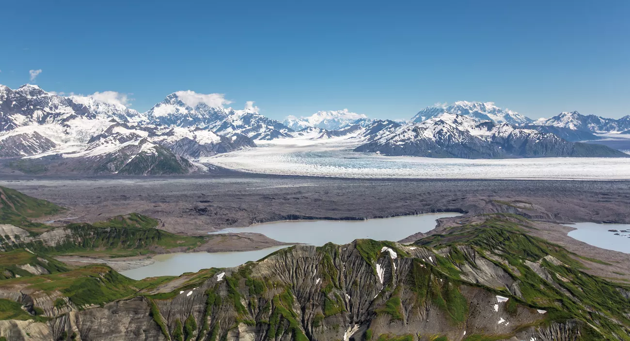
St Elias Mountains, Agassiz Lakes, Libby Glacier and Agassiz Glacier Confluence. NPS / J. Frank
September is National Wilderness Month. The dictionary describes wilderness as: an uncultivated, uninhabited and inhospitable region. For a lot of places in the world, that definition fits perfectly.
Here in the United States, we have a legal definition of the word. The Wilderness Act of 1964 defines wilderness “in contrast with those areas where man and his own works dominate the landscape, is hereby recognized as an area where the earth and its community of life are untrammeled by man, where man himself is a visitor who does not remain.”
Our country has 803 wilderness areas covering more than 111.7 million acres that are part of the National Wilderness Preservation System. This system is managed by the Bureau of Land Management, the National Park Service, the U.S. Fish and Wildlife Service, and the U.S. Forest Service. From the 5.5-acre Pelican Island Wilderness in Northern Florida to the 9.4 million-acre Wrangell-Saint Elias Wilderness in Alaska, a visit can be challenging – but also awe inspiring.
Imperial Russia was first

Vitus Bering's expedition being wrecked on the Aleutian Islands in 1741. Unknown artist. Public domain.
Interestingly, the first formal survey of Alaska was conducted by the Russians, back in 1743, when the control of the continent was contested by the imperial powers of England, Spain, France and Russia. A Russian/Danish cartographer and explorer named Vitus Jonassen Bering was the first to attempt mapping the vast wilderness. On his first voyage, he established that the landmasses of Asia and North America were separate. This information shaped the imperialistic plans of the great powers and started the race to claim territory.
Bering’s second expedition successfully mapped some the coastline of Alaska. Unfortunately for Bering, the rigors of exploration by sea cost him his life in 1741. He passed away on an uninhabited island in the Commander Islands group. The island where he died now bears his name, as does the following:
Bering Strait: The waterway that separates Russia from Alaska and connects the Arctic Ocean to the Bering Sea.
Bering Sea: A marginal sea of the Pacific Ocean located between the Russian Far East and Alaska. The sea and the strait are named in his honor.
Beringia: The former land bridge, sometimes called the Bering Land Bridge, that connected Asia and North America during the last ice age, when sea levels were lower.
Bering Glacier: The largest glacier in North America, located in the U.S. state of Alaska.
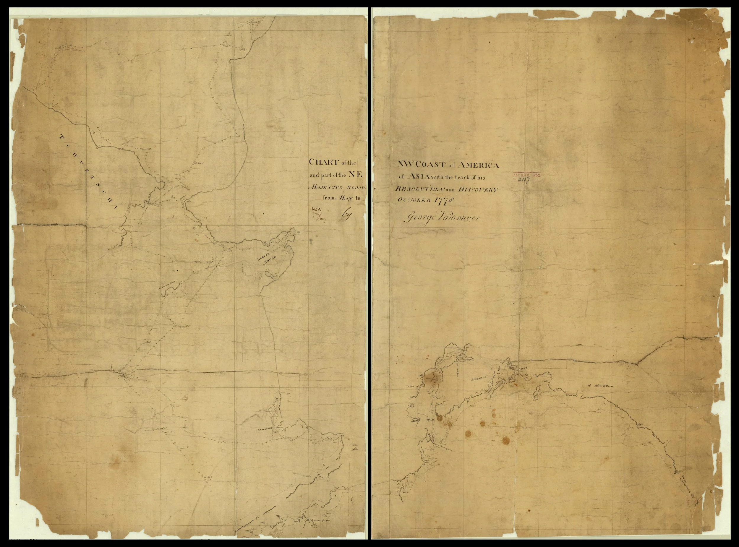
Chart of the NW Coast of America and Part of the NE of Asia with the Track of his Majesty's Sloops 'Resolution' and 'Discovery' from May to October 1778. Vancouver, G. (1778) Chart of the NW Coast of America and Part of the NE of Asia with the Track of his Majesty's Sloops 'Resolution' and 'Discovery' from May to October. [Place of Publication Not Identified: Publisher Not Identified] Retrieved from the Library of Congress,
As a result of Bering’s efforts, Russians began moving to the new territory to make money in the fur trade[1].
Captain Cook and George Vancouver
In 1778, Captain James Cook sailed along the Alaskan coast and charted the Cook inlet in 1778. Cook’s expedition spurred the British to increase their exploration along the northwest coast of Alaska[2] By 1791, the British funded expeditions by George Vancouver, who had accompanied Cook on two of his voyages of exploration.
Vancouver commanded an expedition to explore the Pacific region, including Australia, New Zealand, Tahiti and Hawaii, as well as the Pacific coast near British Columbia. Later, he made several expeditions to explore the Pacific Coast of British Columbia and Alaska.
It didn’t take long for the ruling powers to see that the territory of Alaska was resource-rich – copper, gold, timber, fish and wildlife were worth fighting over.
Imperial struggles over Alaska were primarily a geopolitical rivalry between Russia and Great Britain during the 19th century, which ultimately led Russia to sell the territory to the United States. The U.S. acquisition of Alaska in 1867 was not only a real estate transaction but a strategic move by the Americans to check British expansion in North America.
13.2 million acres of National Park
The Wrangell-St. Elias National Park is the U.S.’s largest at 13.2 million acres– equal to six Yellowstones. The 9-million acre Wrangell-St. Elias Wilderness lies within this national park. Within this wilderness, only a few roads cut through the wilderness, allowing access to experienced hikers.

This wilderness allows visitors to settle back and appreciate the beauty and grandeur of the park. Four major mountain ranges meet in the park -- The Wrangells, Chugach, Saint Elias and Nutzotin / Mentasta mountain ranges that include nine of the 16 highest peaks in the United States. Mount Wrangell remains an active volcano and puffs of steam can be seen rising from its summit, deep in the wilderness.
This incredible land is preserved for our enjoyment, and it’s a great time to get out an explore the Wrangle-St. Elias wilderness before winter – or just go to the Wilderness Preservation System website and find the nearest wilderness to you. It’s well worth the trip.
Who knows – you may even find a Berntsen survey monument marking the boundary of the park!