Ancient Origins of Surveying and Engineering

The approximately 3,700-year-old cadastral survey Si.427, which shows a surveyor’s plan of a field.
The news is filled with new discoveries of very old structures – discoveries made possible by new technology used in land surveying and civil engineering, such as LiDAR, Infrared Thermal Imaging, Ground Penetrating Radar, drones, satellite imagery, GIS and of course, AI. These tools are helping us discover how feats of engineering are not just limited to modern times.
The origins of land surveying and engineering can be traced back thousands of years to ancient civilizations such as the Egyptians, Babylonians, and Greeks.
The Babylonians
The image on the right of a Babylonian clay tablet depicts a surveyor’s plan of a field – dated at circa 3,700 BC. The Babylonians developed a unique form of trigonometry based on their sexagesimal (base 60) number system. Essentially, they constructed a wide variety of right triangles using only exact ratios (no sine, cosine or tangents) — an approach that was extremely useful for surveying.
Ancient Egyptian Surveying
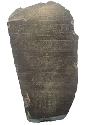
This fragment of the Old Kingdom basalt stele known as the Palermo Stone dated to about 2350 B.C., records the exact flood heights of the Nile River from a near the end of the Egyptian Fifth Dynasty. The stone not only bears this accurate flood data, along with a full King List from the first Pharaoh, Menes, there are other historical details of the previous 500 years including a reference to a “numbering of gold and lands.”
The Egyptians invented surveying instruments that were used by other civilizations for millennia.
Egypt likely produced the first known surveyors, known as “Rope-Stretchers” [harpedonaptae in Greek].

This wooden plumb level from the tomb of Sennedjem (ca. 1250 BC.) consists of two short pieces projecting at right angles from a longer slab. A limestone bob is strung from the top of the long slab and the upper short projecting wooden piece.
The ancient Egyptians developed or used surveying instruments such as plumb bobs, measuring ropes, and the merkhet, which was used for astronomical alignment. They also utilized the groma, a right-angle tool for laying out fields, although it is more strongly associated with later Roman engineering. Other tools included simple levels and squares.
Here are a few Egyptian inventions:
Plumb bob: A weight on a string used to establish vertical lines, which aided in sighting, leveling, and checking for verticality.
Measuring ropes
Ropes were the primary tool for measuring land plots, particularly for taxation purposes.
The practice of "rope stretching" or "harpedonaptae" was common.
Merkhet
An instrument used for both surveying and timekeeping, consisting of a bar with a plumb line.
It was used to align with specific stars to find a north-south line or to mark time at night.
Groma
A right-angle device, though more strongly associated with the Romans, the Egyptians likely developed a precursor.
It was used for laying out fields and establishing right angles.
Other instruments
Squares: Simple builder's squares were used for checking right angles.
Levels: Simple levels, potentially using water in a ditch, were used for leveling the land.
The Ancient Greeks

Graphic reconstruction of the dioptra, by Venturi, in 1814.
Ancient Greeks used land surveying for purposes like establishing property boundaries, measuring land for construction, and creating accurate maps. They developed sophisticated tools like the dioptra, a sophisticated instrument for measuring angles and heights, based on advances in geometry. This was a significant step from earlier, cruder methods that relied on ropes, rods, and simple sighting tools.
Greek surveying tools and techniques
Dioptra: Around 120 B.C., the Greeks invented the dioptra, a portable tool used to measure both terrestrial and astronomical angles and heights.
Its development was based on a greater understanding of geometry.
A simpler form had a sighting bar pivoted on a disc with degree marks.
More complex versions, like the one described by Hero, included worm gears and a water level for precise adjustments.
Geometric principles: The Greeks applied advanced geometry to their surveying, enabling them to calculate distances and angles with much greater accuracy than before.
Sighting tubes: Sighting tubes were used to accurately align measurements, a predecessor to the dioptra.
Measuring rods: Surviving measuring rods show that the Greeks used standard units of length, such as the "Royal cubit" for building and land surveying, which was a precursor to the Roman "aroura".
The Romans

Print, circa 1900, of Roman Aqueduct at El Puente Segovia, Spain.
Ancient Romans significantly advanced surveying techniques. Roman surveying techniques were instrumental in territorial expansion, military logistics, and infrastructure development, influencing subsequent civilizations’ approaches to land management and engineering.
See more about Roman surveying and engineering here:

Page from the Domesday Book for Warwickshire
Middle Ages to Renaissance: Evolving Techniques
During the Middle Ages, land surveying became essential for feudal societies to establish property ownership clearly. Monastic communities played a significant role in refining surveying techniques, meticulously mapping their extensive lands, forests, and agricultural resources. Surveying manuals like England’s “Domesday Book,” compiled in 1086, illustrate the critical role surveying played in taxation, property management, and dispute resolution.
The Renaissance marked another significant leap forward, characterised by remarkable advancements in scientific understanding and instrument innovation. The invention of more precise instruments, such as the theodolite in the 16th century by Leonard Digges, allowed surveyors to measure angles with unprecedented accuracy. The increased precision enabled detailed urban planning, facilitating the creation of sophisticated maps and extensive city development.
Today’s technology makes the future possible
Today, technology is transforming surveying and engineering, by combining powerful computing power with tools such as GIS and RFID. This enables the creation of accurate visual twins of any type of project, making planning and execution smoother and more predictable. Combining RFID with geographic information systems (GIS) grounds digital representations in reality by connecting the digital to the physical, delivering essential information needed for construction, maintenance and recovery. Learn how this technological advancement can help manage any type of asset - from infrastructure assets to fish and wildlife.