It’s National Surveyor’s Week
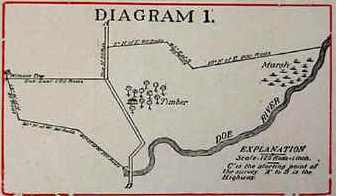
Colonial map created using metes and bounds.
This week, we recognize a profession that has been instrumental in the growth of our country. Land surveying is an on-going, massive project that has mapped more than 1.5 billion acres of public land since the late 18th century, primarily using the Public Land Survey System (PLSS). During Colonial times, surveyors (including Thomas Jefferson) used the system of metes and bounds, which relied on measuring distances between geographic features such as rocks, trees and so on. Later on, surveyors used a grid system developed by Jefferson, to map the vast territories west of the original 13 colonies.
Surveying was a physically demanding profession that required skill, precision and determination – much as it does today. Early surveyors were essential for westward expansion, while modern professionals utilize GPS, robotics, and drones to define property boundaries, infrastructure, and environmental management.
Interesting facts about land surveying in the U.S.:

This image is a work of a Bureau of Land Management employee, taken or made as part of that person's official duties. The image is in the public domain in the United States.
The Great Grid System: The Public Land Survey System (PLSS), initiated after the 1785 Land Ordinance, organized most of the U.S. into a massive grid of townships and sections to facilitate orderly land sale. The first surveys under this system were in eastern Ohio in an area called the Seven Ranges. The origin point now lies underwater on the state line between Ohio and Pennsylvania. Because it is submerged, a monument commemorating the point is adjacent to the nearest roadway and located on the state line between East Liverpool, Ohio and Ohioville, Pennsylvania. The area around the marker was designated a National Historic Landmark in 1965
The Original Surveyor President: George Washington was a professional surveyor long before becoming the first President. At age 17, he received a commission from the College of William and Mary as a professional surveyor for the newly formed Culpeper County. By 1750 (just one year later), he abandoned that position but continued to survey for the next three years. He completed at least fifty more surveys (often related to his own property).
Massive Scale and History: Immediately following the Declaration of Independence on July 4,1776, the new States confiscated the lands of those people who remained loyal to the English Crown, and declared such lands State property. In this way, the States became owners of millions of acres of public domain within their own boundaries and under their jurisdiction. These confiscations included lands in the western territory that were later sold to pay debts and raise revenue. Much of the land was used to pay the soldiers who fought in the war.[1]
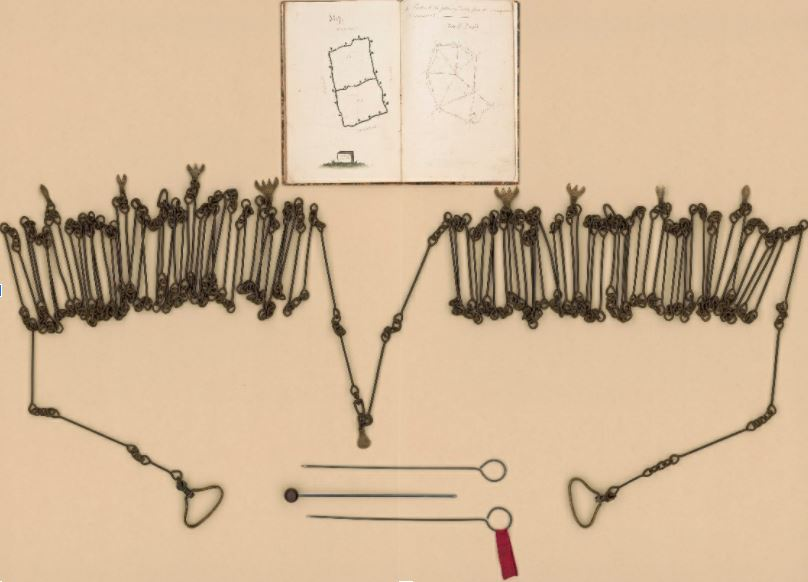
A 66 foot long Gunters Chain used for 18th century metes and bounds surveying in the colonies. Library of Congress, Geography and Map Division. G9900 18– Vault
William Young invented the American Surveying Transit in 1831 - this is apparently the first, or one of the first, transits that Young built.
Management of vast public lands
Later, after the PLSS became law, more than 1.8 billion acres of public domain land were acquired, requiring surveying projects that lasted centuries. The Bureau of Land Management (BLM) still holds records for these surveys dating back to 1785.
Land Surveying Instruments: Since the 1600s, technology has made an impact on how surveying is conducted through the years. (below paraphrased from A History of the Rectangular Survey System by C. Albert White of the U.S. Department of the Interior Bureau of Land Management):
Gunter’s Chain: Historically, PLSS land was measured with a "Gunter’s chain," providing a standardization to measurements. An 1813 surveying text notes that, in New England, most work was done with a magnetic compass and a surveyor's chain.
The chain was invented in 1620 by Edmund Gunter, an Englishman. It was made of 100 iron or steel links and was 66 feet long. Eighty chains made up one mile. Ten square chains made one acre. Gunter's chain was in universal use until the steel tape measure replaced it in the last decades of the 18th century.
The transit was first made in 1831 by Philadelphian William J. Young. It was an adaptation of the theodolite invented in 1720 by John Sisson of England. Sisson had combined a telescope (invented circa 1608), a vernier - a device for subdividing measurements by 10ths (1631) and a spirit level (1704) -into a single instrument.
Young's improvement was to permit the telescope to revolve, or transit, upon its axis. This is a useful feature when prolonging straight lines or taking repeated readings to confirm accuracy. Improved versions of Young's transit were still in use for land surveying in the 1950s and are still broadly used in the construction trade.
A 19th century compass measurement that came within 60 seconds was acceptably accurate. Modern electronic instruments are accurate to within one second (a second is 1/3,600 of a degree).

Depiction of how GIS, GPS and RFID work together to create a map of infrastructure assets.
Electronic Distance Meters: The most stunning breakthrough of modern technology has been in the measurement of distance. Electronic Distance Meters (EDMs) have replaced the steel tapes. EDMs operate on the basis of the time it takes a signal to travel from an emitter to a receiver, or to reflect back to the emitter. Short range EDMs use infrared signals. EDMs designed for distances from 2 to 20 miles use microwaves.
GPS became a significant part of surveying in the early to mid-1980s, with the National Geodetic Survey (NGS) conducting the first GPS surveys in 1983. While the technology was developed in the 1970s for the military, surveyors adopted it for high-precision, efficient, and cost-effective horizontal positioning, completely changing surveying methods by the late 1980s.
Acceleration of technology transformation
Today, technology is making a huge impact on surveying. These technologies, along with AI, are revolutionizing the world of surveying.
Global Navigation Satellite System (GNSS) is a space-based network that provides worldwide, 3D, 24/7 position, navigation, and timing data to receivers. By triangulating signals from multiple satellites, GNSS offers high-accuracy, real-time location tracking for transportation, farming, surveying, and logistics.
Ground Penetrating Radar (GPR) uses radar pulses to image the subsurface. It is a non-intrusive method of surveying the sub-surface to investigate underground utilities such as concrete, asphalt, metals, pipes, cables or masonry.
LiDAR (Light Detection and Ranging), a laser scanning system used with drones for wide range spatial scanning.
3D Laser scanning for close-up highly detailed spatial data.
Total Stations , a surveying instrument that combines an electronic theodolite (for measuring angles) and an electronic distance meter (EDM) to measure both horizontal and vertical angles, as well as distances between points.
Geographic Information Systems (GIS), a computer system that analyzes and displays geographically referenced information. It uses data that is attached to a unique location
Radio Frequency Identification (RFID), works with GIS and GPS to verify the identify and location of any asset
With all the technological advances, surveying continues to be a thriving industry. In 2025, its estimated value was $11.5 billion.[2] The sector is experiencing steady growth driven by infrastructure projects, urban development, and increased use of technology like GNSS and drones. Additionally, the specialized land surveying equipment market in the U.S. is valued at over $2 billion.
It’s a great time to be a surveyor – whether you enjoy working outdoors or prefer data analysis, surveying provides an interesting, fulfilling and important career. Berntsen has worked right alongside surveyors for more than 50 years, providing high-quality products and superior customer service. We’re proud of our long history of assisting surveyors and we look forward to another 50 years supporting the important work of surveying.
Footnotes:
[1] https://www.blm.gov/sites/default/files/histrect.pdf
[2] https://www.kenresearch.com/industry-reports/usa-land-surveying-equipment-market
Header image: https://colonialbrewer.com/my-impressions/the-colonial-surveyor/