April is safe digging month
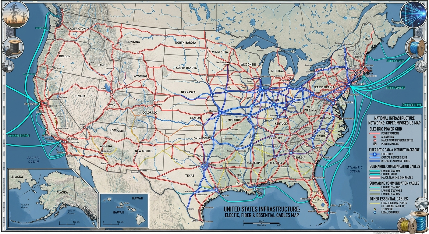
More than 180 million miles of electrical, telephone, and cable lines crisscross the United States[1]. More and more new developments are “undergrounding” cables to improve aesthetics and improve resilience during intense weather.
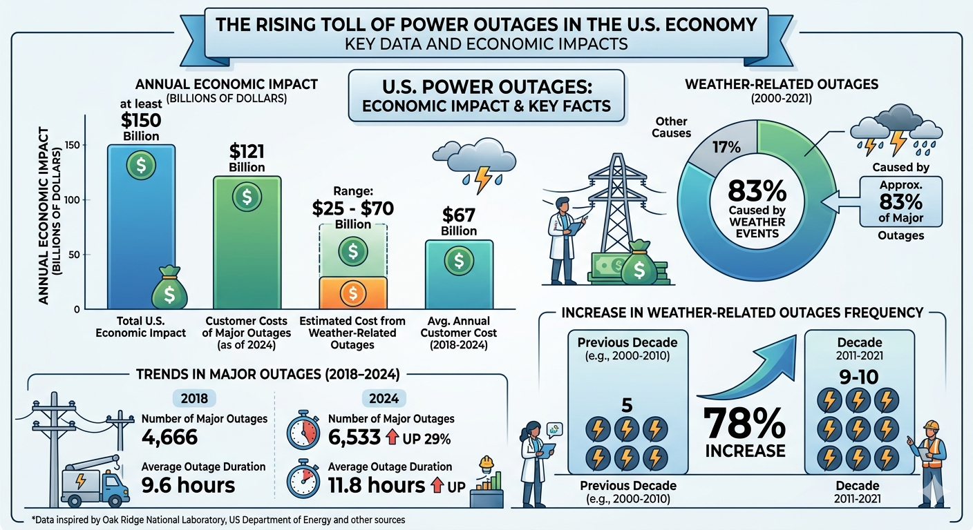
Weather-related power outages cost the U.S. economy an estimated $25 billion to $70 billion annually in direct costs, with total economic impacts from all power disruptions, heavily driven by weather, often exceeding $150 billion per year. Severe weather, including high winds and ice, causes 83% of major blackouts, a number that is rising[2].
Key Findings on Annual Costs:
Total Economic Impact: The U.S. Department of Energy (DOE) estimates that power outages cost the U.S. economy at least $150 billion annually.
Weather Component: Approximately 83% of major outages between 2000 and 2021 were caused by weather, resulting in an estimated annual cost of $25 - $70 billion.
Growing Trend: Between 2011 and 2021, the average annual number of weather-related outages increased by 78% compared to the previous decade.
Recent Data: As of 2024, the annual burden of major outages reached $121 billion
Scenic America calculates that nationwide, undergrounding could save $17.1 billion per year in lost economic activity due to power outages.
Makes sense, but . . .

Undergrounding cables makes sense – but it must include GIS mapping and an effective way to locate, identify and verify buried cables. Development is on-going which means repeated excavation in areas where cables, gas lines, fiber and water/sewer lines are buried. The Common Ground Alliance (GCA) estimates that accidental excavation strikes of buried utilities costs more than $30 billion dollars per year.[3]
The CGA recommends that everyone who is planning to dig – whether homeowners or contractors – contact the nationwide 811 system before excavation begins. Each request will send locators from utility companies who will mark buried utilities with paint and flags. Despite this free service, the leading root cause of most excavation utility strikes is the failure to call 811.
Fortunately, technology is available that can prevent utility strikes. Mapping underground facilities with Geographic Information Systems (GIS) helps contractors know approximately where and what is buried in a specific place. But GIS alone is not enough for precise location and identification of buried utilities. That’s when another technology, Radio Frequency Identification (RFID), can make all the difference. Magnetic RFID tags can be buried with any type of utility and will display its identity, owner and other information with a simple scan. This data can be incorporated into GIS (such as Esri’s ArcGIS) through data collection apps on mobile devices. RFID is agnostic, so it will work with any utility, above or below ground.
RFID and GIS are key
Passive RFID tags don’t require power (they activate only when scanned) so they can last underground for years. A 2022 study describes how RFID has been used to mark and manage utilities over a period of seven years. The study concluded that magnetic RFID marking, coupled with GIS mapping, is a low-cost, reliable solution for underground infrastructure locating and management.
Marking underground utilities with magnetic RFID is a long-term solution that streamlines future utility locating processes while providing the means to connect to digital mapping systems for efficient utility management -- from water pipes to fiber-optic cables. Utility location verified by RFID, provides a highly accurate method for utility owners to manage all of their infrastructure facilities.
With the national trend toward undergrounding cables, the phenomenal increase in data centers and the increasing use of technology, it makes sense to protect buried infrastructure with accurate, site-verifiable RFID markers linked to GIS maps that can let excavators truly know what’s below. Learn more about InfraMarker Connected RFID.
Footnotes: