The Navajo Nation Cadastral Survey
As a surveyor, did you ever have the opportunity to be part of a historic project? Jack Savlan, now of Milwaukee, did. He was one of the surveyors on the original Cadastral Survey of the Navajo Nation that began on June 21, 1982 at the corner of the sections 35 and 36, T24N, R14W, New Mexico Principal Meridian. Jack’s going to take over the blog for today and share this incredible experience.
Those were the days
Blog by Jack Savlan, PLS, Retired Federal Cadastral Surveyor
Looking back on it, I’ve been incredibly fortunate in my career – first, that I discovered surveying, and second that my first job as a surveyor was for the Bureau of Land Management (BLM) working on the Navajo Nation Cadastral Surveying project.
I learned about surveying by accident (like most people). I was working for the U.S. Forest Service where I was assigned to help a crew do some land surveying on the Umpqua National Forest in Oregon. I quickly knew that I’d found my career. Where else could you spend your day in some of the most beautiful land in the country, get to use math and operate precision instruments?
I studied at the Oregon Institute of Technology and graduated in 1982 with a bachelor’s degree in Civil Engineering, Surveying emphasis.
Surveying the Navajo Nation
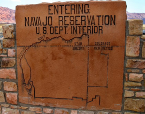
The Navajo Nation comprises an expanse of land about the size of West Virginia, and is located within Arizona, New Mexico, and Utah. In 1982 nearly all of these lands were without a Cadastral Survey. This lack of location specificity caused inconvenience for the Nation, as it’s hard to govern economic development without defined and monumented boundaries. The Cadastral Survey provides a definitive description, allowing the Nation to define boundaries for land development, and provides points of reference for residential surveys. The Cadastral Survey is a framework for future development. Plus, it’s permanent. Even the Supreme Court can’t change a Cadastral Survey.
The BLM, the Bureau of Indian Affairs, and the Navajo Nation worked together to succeed in a monumental effort. Our survey crews were made up of one BLM Cadastral Surveyor and at minimum two Navajo Land Department Survey Technicians. The Navajo Reservation is the largest reservation in the contiguous United States and includes arid lands, alpine forests, mesas, and mountains reaching as high as 10,348 feet.
And quicksand. My crew discovered this when we inadvertently stopped our vehicle in the bottom of Chaco Wash, and quickly noticed it was starting to sink. Miraculously some plywood was nearby, which we were able to ‘panic-speed’ get under the tires. Having 4-wheel drive allowed us to then crawl our vehicle out. We made this blunder only once.
Transportation within the Navajo Nation was our biggest challenge

Jack Savlan NIR Surveying in 1983.
During my time, all of the work was performed before the development of GPS. To navigate to the area of the job site we needed to become expert readers of the US Geological Survey (USGS) topographical maps, as well as use of magnetic compasses. Because of GPS, these skills are today not as critically important.
Terrain was rough, so two four-wheel drives frequently traveled together. Typically, one of the vehicles was BLM, the other was an official Navajo Nation vehicle. We carried tow chains, so that if one vehicle became struck, the other would provide tow force to break the first vehicle free. Sometimes a vehicle had a winch, we would keep the winch between the vehicles, so either vehicle could be winched out of difficulty.
Gasoline was always a trick, we relied upon trading posts to refuel. See me in the photo below!

Jack fueling up at the Newcomb Trading Inc.

Daniel Bryan (right) and Barney Woodie (left) setting a monument. Both are Navajo Land Department Technicians and are now retired.
By the book
We did everything based on the 1973 BLM Manual of Surveying Instructions. The first few monuments we set were the standard BLM, but the Navajo Nation decided they wanted the caps to feature their Great Seal, which depicts the four sacred mountains, the sun rising in the east, and arrowheads symbolizing their protected status within the United States.
Bill Rushing, Berntsen’s Vice-President of Product Development, created two versions of a custom brass cap, and both captured the seal beautifully. The version with raised lettering and raised seal was voted-in, and used continuously during the life of the project office. Berntsen riveted the caps on 30” stainless steel posts. As a memorial we set Berntsen Deep1 magnets beneath all the monuments.

The cap on the left is the approved version of the marker with raised lettering; the version on the right is the version that was voted down (with engraved lettering)
Photo used by permission, BLM Indian Lands Surveyor, BIA Navajo Region.

A freshly-set Berntsen monument, circa 1983.
A truly memorable experience with lasting impact

Close-up of the plaque highlighting the unique partnership that made the Cadastral Survey possible.
Looking back on my career, including surveying continuously from 1982 to 2016, the two and one-half years I spent with the Original Cadastral Survey of the Navajo Reservation were the most memorable. Thousands of the Navajo Nation brass caps were set by the project office. I believe I personally set a few hundred of them.
A plaque commemorating the early years of the project office is displayed outside of the Navajo Nation Council in Window Rock, Arizona.
This was a unique experience where I met and worked with wonderful people, some of whom became life-long friends. The land in which we worked is beautiful beyond description. With great heartache I need to report the Navajo Cadastral Project Office was officially closed on January 28, 2020. It would be difficult to match this experience in today's world.
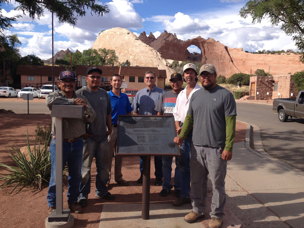
This picture was taken in 2014, when the AZ Deputy Director got involved with BLM Cadastral, and got a taste of what we do at the project office and got some field experience as well. Left to right, Daniel Bryan, Senior Engineering Tech, Byron Shorty, Engineering Tech, Gerald Davis, AZ Cadastral Chief, Geoff Graham, AZ Field Section Chief, Kevin Tso, Engineering Tech, Mark Searles, Survey Tech, and Fabian Yazzie, Cadastral Land Surveyor/Project Manager.
Photo used by permission, BLM Indian Lands Surveyor, BIA Navajo Region.

Image of a monument cap set in 2005.
Thank you, Jack (and consultant Fabian Yazzie, BLM Indian Lands Surveyor), for sharing this incredible experience!
With all the surveying that’s been done in the past 40 years, I’m sure there are many other stories to share. If you have a surveying experience you’d like to share, just email me at email@berntsen.com, and I’ll work with you to develop a blog to share with your colleagues!