
News and Events
Archive
- May 2025
- April 2025
- March 2025
- February 2025
- January 2025
- December 2024
- November 2024
- September 2024
- August 2024
- July 2024
- June 2024
- May 2024
- April 2024
- March 2024
- February 2024
- January 2024
- December 2023
- November 2023
- October 2023
- September 2023
- August 2023
- July 2023
- June 2023
- May 2023
- April 2023
- March 2023
- February 2023
- January 2023
- December 2022
- October 2022
- August 2022
- July 2022
- June 2022
- May 2022
- April 2022
- March 2022
- February 2022
- January 2022
- December 2021
- November 2021
- October 2021
- September 2021
- August 2021
- July 2021
- June 2021
- May 2021
- April 2021
- March 2021
- February 2021
- January 2021
- December 2020
- November 2020
- October 2020
- September 2020
- August 2020
- July 2020
- June 2020
- May 2020
- April 2020
- March 2020
- February 2020
- January 2020
- December 2019
- November 2019
- October 2018

Yellowstone's Moving Monuments
Yellowstone was established by Congress as the world’s first national park on March 1, 1872, following three expeditions to the region (the Folsom-Cook-Peterson Expedition of 1869; the Washburn-Langford-Doane Expedition of 1870; and the official, government sponsored Hayden Expedition of 1871). The expeditions were seeking the truth to the numerous rumors about the area that was described as “smoking with the vapor from boiling springs; and burning with gasses . . . “ (Joe Meek, fur trapper, 1829). What the men of these expeditions saw astounded and inspired them. The unique geology of the area galvanized them to petition Congress to set the area aside as a “public pleasureing-ground” protecting from “injury or spoliation” the “timber, mineral deposits, natural curiosities or wonders within said park, and their retention in their natural condition.”

Underwater by Design
Near midnight on August 4th, 1984, the M/V Wellwood, a 400-foot steel-hulled freighter, struck Molasses Reef in the Florida Keys National Marine Sanctuary. This wasn’t good for the Wellwood, and it was disastrous for Molasses Reef; 1,280 square meters of coral reef habitat was Molasses Reef / Wellwood Restoration Site Monument utterly destroyed, reduced to pulverized coral rubble.
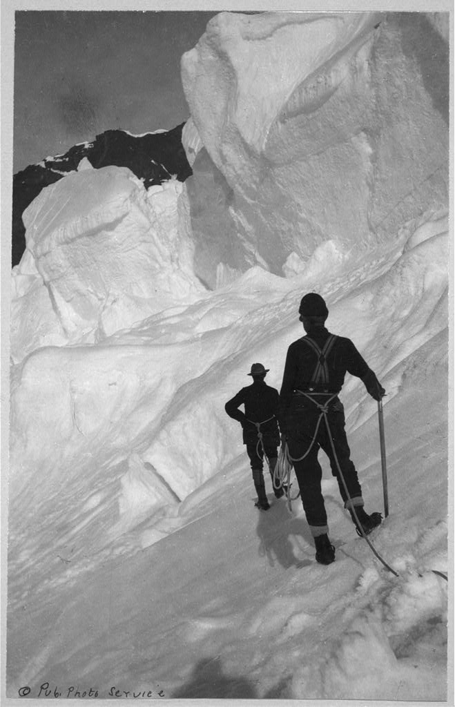
Denali . . . Maybe not just a hike up the mountain
In June of 1989, a team of eight men ─ formally called The 1989 Mt. McKinley Global Positioning Expedition ─ set out from a base camp to perform one of the most unusual survey projects the world has ever seen. Their mission was to verify, by the most sophisticated satellite positioning methods, the true summit elevation and position of the highest mountain peak on the North American continent, Denali. [Mt. McKinley was renamed with its original name, Denali, in 2015]. The project involved hundreds of hours of planning, thousands of dollars in costs, the use of the most up to date global positioning equipment to track several special military communication satellites orbiting the earth . . . and one Berntsen Survey Monument, which was placed precisely at the summit.

The survey that led to a national park
At the beginning of nearly every autumn season, I set out on vacation, hoping to see new places and learn new things. I often seek out new territory as I did this year, but I also found myself trekking back to a much favored area in Utah: Zion National Park. Although I’ve been there in the past for sightseeing and hiking its impressive rock trails, it is always a joy to visit. And this time, I’d like to especially thank Leo Snow.

Lasting Impressions of Surveying
National Surveyor’s Week is an opportunity to highlight the many benefits of a career in surveying and to celebrate the accomplishments of the surveying community. Over the past year, I’ve been highlighting the work of colonial surveyors, from John Morton to Thomas Jefferson. These early surveyor’s contributions extend far beyond surveying boundaries – their background helped them to literally lay the foundation of our nation.

InfraMarker® by Berntsen Awarded the Esri Release Ready Specialty Designation
Berntsen International, the leader in infrastructure marking solutions, announces that it has earned the Esri Release Ready Specialty status. This designation recognizes companies, products and solutions that integrate with Esri technology and are created by partners with expertise in leveraging Esri solutions and software.

The Navajo Nation Cadastral Survey
As a surveyor, did you ever have the opportunity to be part of a historic project? Jack Savlan, now of Milwaukee, did. He was one of the surveyors on the original Cadastral Survey of the Navajo Nation that began on June 21, 1982 at the corner of the sections 35 and 36, T24N, R14W, New Mexico Principal Meridian. Jack’s going to take over the blog for today and share this incredible experience.

Drawing the Mason-Dixon Line
In 1632, Maryland (governed by the Calvert family) was granted “that part of the Bay of Delaware which Lieth under the Fortieth Degree of North Latitude”. Unfortunately, the fortieth parallel ran right through the middle of Philadelphia, cutting it off from its only harbor. Pennsylvania (governed by the Penn family), didn’t think this was fair, and the case dragged out in English courts for decades. By 1750, a boundary was agreed upon - on paper.

2020 was tough, but I'm grateful
I was on the back ridge of maples where a large 30” hemlock stands; the branches were covered with snow – it looked like a Christmas card! Birds were chirping and the tracks of deer, fox and snowshoe rabbits were outlined in the pristine, crunchy snow. An eagle made a slow, silent arc overhead. I couldn’t think of anywhere in the world I’d rather be than on this plot of land in the forest.

Remonumenting - a solid foundation for economic growth
As any surveyor knows, our nation was built on surveying, with many of our early leaders getting their start as surveyors (Washington, Lincoln and Jefferson, to name a few). Early surveyors laid the essential groundwork for land records that have served us well for many years. Unfortunately, land records in many states are based on original surveys done in the 1800s or even earlier. That’s fine when land remains unchanged for decades . . .