
News and Events
Archive
- May 2025
- April 2025
- March 2025
- February 2025
- January 2025
- December 2024
- November 2024
- September 2024
- August 2024
- July 2024
- June 2024
- May 2024
- April 2024
- March 2024
- February 2024
- January 2024
- December 2023
- November 2023
- October 2023
- September 2023
- August 2023
- July 2023
- June 2023
- May 2023
- April 2023
- March 2023
- February 2023
- January 2023
- December 2022
- October 2022
- August 2022
- July 2022
- June 2022
- May 2022
- April 2022
- March 2022
- February 2022
- January 2022
- December 2021
- November 2021
- October 2021
- September 2021
- August 2021
- July 2021
- June 2021
- May 2021
- April 2021
- March 2021
- February 2021
- January 2021
- December 2020
- November 2020
- October 2020
- September 2020
- August 2020
- July 2020
- June 2020
- May 2020
- April 2020
- March 2020
- February 2020
- January 2020
- December 2019
- November 2019
- October 2018

Happy Surveyor’s Week!
Since people have owned land, surveying has been an essential profession. The earliest evidence of surveying, potentially going back to 11,000 years ago, is found at the Nabta Playa site in southern Egypt, related to the construction of large megalithic structures.

Looking forward to prosperity
It’s been a busy year, and a very good year for the US economy. In fact, according to RSM, over the past eight quarters, the American economy has grown at an annualized 2.9%. This performance is striking in comparison to other countries. For example, the EU’s growth during this same period was just 1.9%. The biggest economy in the EU is Germany, and its economy shrunk by 2% during the same period.

One Point Fits All
In 1996 Georg Rothbucher was visiting a customer at a construction site who was facing a difficult problem. Two thousand square meters of concrete had been poured incorrectly for the Finished Floor Level (FFL) of a new building. This surveyor was trying to recover the original reference point used to set the FFL – a chalk mark, pencil line or a nail.

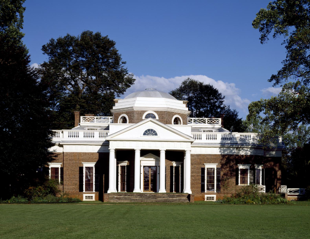
Richard Caswell, Surveyor and Father of North Carolina
Many of our founding fathers started their careers as surveyors. Along with providing an essential service, surveying was a very profitable trade in eighteenth century America. Surveyors would purchase newly opened land from the Crown and sell tracts to settlers at higher prices. This led to some resentment and suspicion by settlers – but one surveyor remained popular throughout his surveying career – and beyond.

Surveyor and friend to Washington
Surveyors including George Washington, Thomas Jefferson and Abraham Lincoln, were key to establishing the United States as a nation. Surveying in the 1700s and 1800s was both arduous and perilous. For example, one of Washington’s contemporaries, William Crawford, met a tragic end at the forefront of western expansion of European settlers in lands controlled by Native Americans.

Geodesy and the Summer Solstice
Today is the Summer Solstice, the longest day of the year (in the Northern Hemisphere). Because Earth’s axis of rotation is tilted about 23.4 degrees relative to its orbit around the sun, this means that the different parts of the Earth receive the amount of light based on the position of the earth in its orbit around the sun. This tilt causes the earth’s seasons - From March to September, the Northern Hemisphere tilts more toward the sun, creating spring and summer, while in the Southern Hemisphere it’s fall and winter.

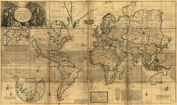
Surveying the Roman Empire
Did you know that the term “geodesy” was coined by Aristotle in about 350 BC? The term is derived from the Greek word ge, which means earth, and deo, which means to divide land. He created that name to differentiate it from the field of mathematics, called geometry in ancient Greek, (ge for “earth” and metry, meaning “to measure”). Essentially, geodesy means applied math.

Major John Wesley Powell – Surveyor, cartographer, explorer, geologist, ethnographer and botanist
This Memorial Day, thousands of tourists will be visiting the Grand Canyon, which became a national park in 1919. As with many other national parks, surveyors played a vital role in preserving this spectacular landscape for everyone to enjoy.

Tree surveys - more important than ever
Before the arrival of European immigrants in the United States, forests totaled about 1.05 billion acres, or about 43 percent of the country. Clearing of forest land in the East between 1850 and 1900 averaged 13 square miles every day for 50 years.
Presidents and surveyors led the way
President’s Day has been a federal holiday since 1879 when it was instituted to memorialize the birthday of George Washington, born on February 22, 1732. By the 1970’s, the holiday had evolved to commemorate all US Presidents.
In the 1920s, a historian for the state of South Dakota came up with the idea of creating a massive sculpture that featured heroes of the American West to increase tourism in the area.

Thank you, surveyors and Eagle Scouts
Back in February 2021, 15-year-old Henry Spoering asked Berntsen to help support his Eagle Scout project creating an Orienteering Course at Camp Waluhi'yi in Duncan, Oklahoma. He’d heard about Berntsen’s support for young surveyors from his project sponsor, Marcus Heilman, PLS, of Section 37 Surveying and Mapping. Henry is a seasonal employee of Section 37, so Henry approached the project like any other, applying the skills he’d already learned.

Hoover Dam - a wonder of surveying
The dizzying pace of technological change is overwhelming at times. But no matter what changes, surveyors keep us grounded, because they know precisely where we stand, X, Y and Z. Surveyors have been setting the markers for progress since ancient times – the early Egyptian and Roman architectural wonders were based on the work of early surveyors. Colonial surveyors were key to the founding of the United States, not only by parsing out boundary lines for European settlers, but by nation-building – helping to author the Declaration of Independence, then helping to create a new kind of government for the new nation.

Steve Parrish ‒ A Living Legend
I’m sure most surveyors have heard of the “Final Point” program created by Berntsen International, Inc. and the National Society of Professional Surveyors Foundation (NSPSF). It’s a way to memorialize the work of beloved surveyors who have had a lasting impact on the profession, while supporting the future of surveying through NSPS/Berntsen scholarships.

April is Safe Digging Month - for good reason.
As surveyors intimately understand, it’s very important to know what’s below. Your life could depend on it. National Safe Digging Month was created in 2008 by the Common Ground Alliance (CGA) to bring visibility to protecting workers, utilities and the public by working to prevent utility strikes during excavation. This group is comprised of companies and individuals in every facet of the underground utility industry, including Berntsen.

Yellowstone's Moving Monuments
Yellowstone was established by Congress as the world’s first national park on March 1, 1872, following three expeditions to the region (the Folsom-Cook-Peterson Expedition of 1869; the Washburn-Langford-Doane Expedition of 1870; and the official, government sponsored Hayden Expedition of 1871). The expeditions were seeking the truth to the numerous rumors about the area that was described as “smoking with the vapor from boiling springs; and burning with gasses . . . “ (Joe Meek, fur trapper, 1829). What the men of these expeditions saw astounded and inspired them. The unique geology of the area galvanized them to petition Congress to set the area aside as a “public pleasureing-ground” protecting from “injury or spoliation” the “timber, mineral deposits, natural curiosities or wonders within said park, and their retention in their natural condition.”

Underwater by Design
Near midnight on August 4th, 1984, the M/V Wellwood, a 400-foot steel-hulled freighter, struck Molasses Reef in the Florida Keys National Marine Sanctuary. This wasn’t good for the Wellwood, and it was disastrous for Molasses Reef; 1,280 square meters of coral reef habitat was Molasses Reef / Wellwood Restoration Site Monument utterly destroyed, reduced to pulverized coral rubble.
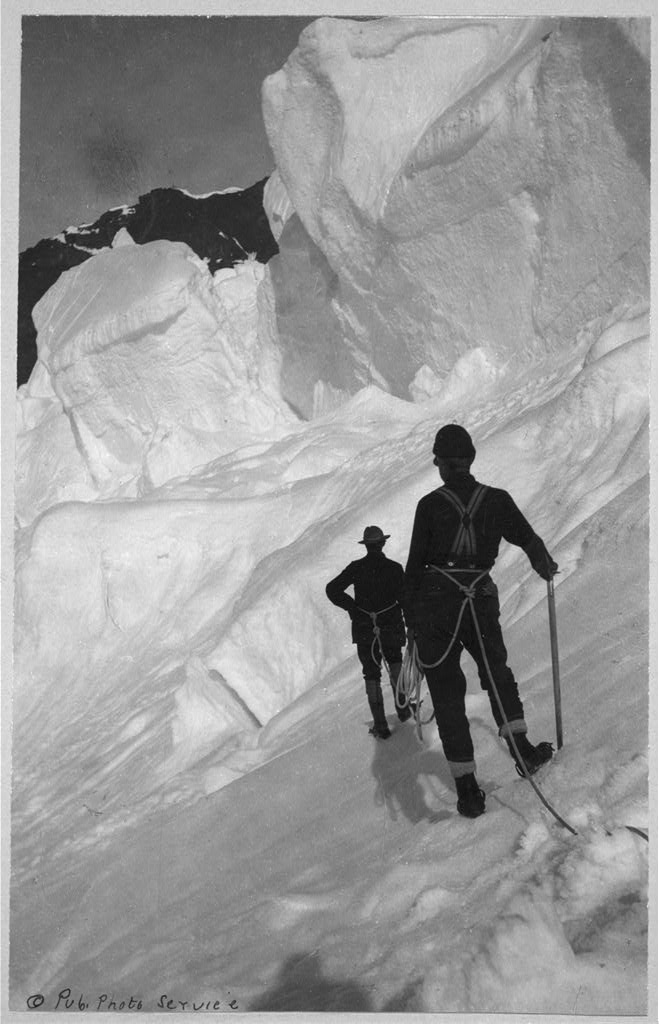
Denali . . . Maybe not just a hike up the mountain
In June of 1989, a team of eight men ─ formally called The 1989 Mt. McKinley Global Positioning Expedition ─ set out from a base camp to perform one of the most unusual survey projects the world has ever seen. Their mission was to verify, by the most sophisticated satellite positioning methods, the true summit elevation and position of the highest mountain peak on the North American continent, Denali. [Mt. McKinley was renamed with its original name, Denali, in 2015]. The project involved hundreds of hours of planning, thousands of dollars in costs, the use of the most up to date global positioning equipment to track several special military communication satellites orbiting the earth . . . and one Berntsen Survey Monument, which was placed precisely at the summit.

The survey that led to a national park
At the beginning of nearly every autumn season, I set out on vacation, hoping to see new places and learn new things. I often seek out new territory as I did this year, but I also found myself trekking back to a much favored area in Utah: Zion National Park. Although I’ve been there in the past for sightseeing and hiking its impressive rock trails, it is always a joy to visit. And this time, I’d like to especially thank Leo Snow.

Lasting Impressions of Surveying
National Surveyor’s Week is an opportunity to highlight the many benefits of a career in surveying and to celebrate the accomplishments of the surveying community. Over the past year, I’ve been highlighting the work of colonial surveyors, from John Morton to Thomas Jefferson. These early surveyor’s contributions extend far beyond surveying boundaries – their background helped them to literally lay the foundation of our nation.
Before there was President's Day, there were surveyors
Whenever President’s Day rolls around, we, as surveyors, can’t help but think of the historical importance of surveying in the United States – not only because Washington, Lincoln and Jefferson were all surveyors, but the impact surveying had on the development of the nation. I’ve touched on that in blogs I’ve done about colonial surveyors, but the depth of the subject calls for a look into how surveying developed in America.