It's World Creativity and Innovation Day
I was surprised to learn that there is such a thing as World Creativity and Innovation Day, and even more surprising, it’s today, Wednesday, April 21.
The United Nations passed a resolution creating this day to celebrate the creative economy. This celebration is fitting for today’s environment, considering the entire world was forced to get resourceful with our jobs during the pandemic.
Fortunately, surveyors have made creativity a way of life. It seems like we have a pretty straightforward job – use our tools to verify property lines, monitor structures for movement over time, lay out the lines for construction, etc.
In reality, it’s anything but straight-forward.
As surveyors, we sometimes need to get a little creative too. It’s important to have the right tools in our field bag. We all try to plan accordingly and take the right tools in the woods with us, but . . .we often find ourselves relying on our most important tool (our brain) to figure out a way get the job done because the conditions at our destination were unexpected. No one wants that dreaded second trip back out to the truck and in again, especially if it’s more than a half mile away.

I remember a few times when I’ve gotten resourceful. Back when GPS was really hindered by tree canopy, I remember stacking numerous range poles on top of one another to try to get the rover receiver up above the canopy. Admittedly, I’m sure we added some error by increasing our rod height but it was still within tolerances for the use of the data. I certainly would NOT recommend that practice for anything you want sub-centimeter accuracy on…so kids, don’t go trying that one at home!
Another time, I forgot a hand trowel and was needing to dig up a corner just under the surface. This was a bit difficult because we had extremely dry conditions, so the ground was much harder than normal. I rung up the corner with the locator and used my plumb bob to loosen up the surface and then dug it out with my hands. Yes, I still use a plumb bob…not very often, but it’s one item that I always have in my vest.
While range poles and plumb bobs may be some more rudimentary tools, adding technology to creativity brings innovation into reality, as I’ve found at Berntsen.
At Berntsen, I’m still involved in approaching work with an innovative, problem-solving mind-set.
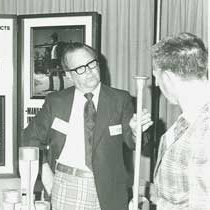
Phillip Peterson with the W-1-B Magnetic Aluminum Monument at a tradeshow in the 70s.
The company itself was founded on a novel invention. Phil Peterson and Peter Berntsen created the first modern geodetic monument, a lightweight, magnetic aluminum survey monument that was easy to carry in to the field and easy to set. Berntsen, a metallurgist, made sure that the aluminum and alloys used were metallurgically sound so the monument didn’t “self-destruct” in the ground.
Now, nearly 50 years later, I’m working with customers to deploy another unique Berntsen invention – the InfraMarker system. InfraMarker uses RFID and software to physically mark and digitally manage just about any kind of infrastructure asset, from stormwater assets to gas pipelines to fiber cables. I’ve found that introducing this new approach takes a lot of creativity in itself, because it bridges two worlds – asset managers working with GIS in the office, and field staff who inspect and maintain all kinds of infrastructure assets.
Connecting markers to GIS with RFID
Most organizations understand the benefits of managing assets spread over a geographic area using GIS-based systems. The problem that Berntsen identified is that these systems don’t actually connect the asset with its record in the GIS. This leads to inefficiencies and errors.
Right now, utilities that manage stormwater assets are finding InfraMarker a practical solution in the field.
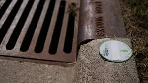
An InfraMarker RFID tag marking a catch basin.
For example, a crew can be sent to inspect/maintain an inlet at a specific location, and easily navigate to that place using GIS and GPS. Unfortunately, upon arrival, they may find more than one inlet in proximity of the digital coordinates. In that case, a lot of time is wasted verifying which asset needs inspection/maintenance. However, if these inlets were marked with an InfraMarker RFID tag, they can be quickly and accurately identified and the associated inspection forms can automatically load in the InfraMarker mobile app.
Not only does RFID accurately identify assets, it connects those assets to the records in GIS.
This means that it can fold into the system that’s already in use, making life easier for folks in the field while giving the office managers what they need to do their jobs better.
It’s a lot of fun to be a part of a company that’s solving problems using creative approaches. Don’t hesitate to contact me at email@berntsen.com if you’re interested in learning more about the InfraMarker Connected RFID solution, or you want to share your thoughts on how you would use InfraMarker.