
News and Events
Archive
- May 2025
- April 2025
- March 2025
- February 2025
- January 2025
- December 2024
- November 2024
- September 2024
- August 2024
- July 2024
- June 2024
- May 2024
- April 2024
- March 2024
- February 2024
- January 2024
- December 2023
- November 2023
- October 2023
- September 2023
- August 2023
- July 2023
- June 2023
- May 2023
- April 2023
- March 2023
- February 2023
- January 2023
- December 2022
- October 2022
- August 2022
- July 2022
- June 2022
- May 2022
- April 2022
- March 2022
- February 2022
- January 2022
- December 2021
- November 2021
- October 2021
- September 2021
- August 2021
- July 2021
- June 2021
- May 2021
- April 2021
- March 2021
- February 2021
- January 2021
- December 2020
- November 2020
- October 2020
- September 2020
- August 2020
- July 2020
- June 2020
- May 2020
- April 2020
- March 2020
- February 2020
- January 2020
- December 2019
- November 2019
- October 2018

Smarter Aquaculture Management with RFID
Managing and protecting fish populations is more critical than ever. Aquaculture now supplies nearly half of the world’s farmed and wild fish and the demand continues to surge.

RFID Helps Manage Data Centers
The growing demand for cloud computing, along with surging use of Artificial Intelligence (AI) and the Internet of Things (IoT) is driving investment in data centers – the facilities that house and operate the servers, storage devices and networking equipment that make powerful computing possible.

3 Ways RFID brings magic to your holiday season
This year, Americans will be spending an average of $2,000 per person over the holidays – with more than $600 on travel, and the rest on decorations, celebrations and gifts. For most of us, this translates to a lot of running around and spending money – and enjoying the holidays.
It’s good to know that in the background, little RFID elves have been busy keeping everything running smoothly to help make the holidays truly magical.

Celebrating GIS - the technology that keeps on giving
GIS was first developed in 1963 by Roger Tomlinson who used computers to handle map information for the Canadian government. Since that time, the use of Geographic Information System technology has exploded. According to MarketsandMarkets, the GIS market is expected to reach $14.5 billion by 2025. By 2032, the market is projected to reach about $43.8 billion.

RFID- The silent technology enhancing our lives every day
Radio Frequency Identification (RFID) technology uses radio waves to identify virtually anything. It is a wireless system consisting of an RFID tag and an RFID reader. RFID tags store data that can be read, even from a distance—without making any physical contact or requiring a line of sight.

Disaster response and resilience
A recent survey revealed that many people believe that natural disasters are more frequent and severe than in the past. It turns out that this observation is backed up by facts. According to the National Oceanic and Atmospheric Administration (NOAA), the frequency of natural disasters is increasing year-over-year. There were 28 weather and climate disasters in 2023, surpassing the previous record of 22 in 2020, tallying a price tag of at least $92.9 billion.

It’s 811 Day
This 8/11 is a beautiful Sunday and many homeowners will be using the day to tackle some home improvement projects, such as building a deck, installing a new mailbox or installing a fence. In fact, 74% of homeowners have or will dig on their property on their property this summer. Unfortunately, nearly 40% of these won’t call 811 ahead of time to mark buried utilities.[1]

RFID Improves Data Center Operations
More than 90% of organizations use cloud computing to run enterprise applications[1]. That means that everything from hospitals and first responders to Fortune 500 companies and governments rely on the cloud. Soon, air traffic control and police departments will be cloud-based as well. Society won’t be able to function without the cloud.

AEC Firms embrace RFID
AEC is the acronym for Architecture, Engineering and Construction, which is a collection of services engaged in the planning and execution of all types of construction projects. It’s essentially the term for a deep and intricate collaboration between partners in order to bring any project to fruition.

Owning fossil history with oral tradition and science
Before paleontologists began scouring indigenous lands for proof of evolution in the fossil record, Native Americans had long since incorporated these “new discoveries” into their cultures. Centuries before Europeans arrived, native inhabitants of the Americas understood that the land had once been teeming with massive creatures that ruled the earth, water and sky.

RFID in Revolutionizing Asset Tracking Across Industries
A recent article highlighting the 25 Technologies that have changed the world lists the usual blockbuster inventions, such as the Apple iPhone, Wi-Fi, AI, facial recognition, drones, DNA testing, social platforms, quantum computing and bitcoin. However, not all of these world-changing technologies are so famous. Who knew that Radio Frequency Identification (RFID) is a world-changing technology?

RFID - resilient and adaptable
Radio Frequency Identification (RFID) has been around for a long time. The precursor technology to RFID was originally developed as a musical instrument by the Russian physicist Leon Theremin, patented in 1928. The Theremin produces music by manipulation of electromagnetic fields around two antennae to produce sound.

Key Trends in 2024
The “Fourth Industrial Revolution” is well underway. Back in 2011, economist Klaus Schwab coined the term to refer to the rapid digitization and accessibility of technologies that spark a global shift in processes – in everything from how we communicate to how businesses and governments are managed.

Berntsen Adds NFC capability to the InfraMarker RFID App
Berntsen International, a leading manufacturer of infrastructure marking products, announces that its InfraMarker RFID App now supports Near Field Communication (NFC) and is available on both the Apple App Store and Google Play.

InfraMarker Brings RFID Power to Esri Field Operation Applications
Berntsen International, a leading manufacturer of infrastructure marking products, announces that its InfraMarker RFID app is now fully integrated with Esri’s ArcGIS Survey123 and ArcGIS Field Maps mobile applications.

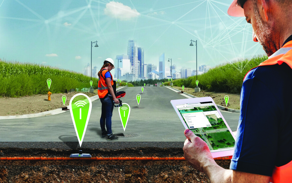
RFID + GIS = SUE Enhancement
Subsurface Utility Engineering (SUE) that leverages Geographic Information Systems (GIS) and Radio Frequency Identification (RFID) deliver substantial benefits in the management and protection of underground assets.

RFID - technology that keeps on giving
We’ve all heard of RFID, a technology that’s been around since the 1930s. Did you know that it’s now one of the fastest-growing technologies in the world?

The InfraMarker® RFID App Now Livein the Esri ArcGIS Marketplace
Madison, Wisconsin – March 7, 2022: Berntsen International, Inc., was recognized with the High Potential Award at the 2022 Esri Partner Conference (EPC) held in Palm Springs, California March 5–7, 2022. This award was presented to Berntsen International Inc., for the substantial opportunity for growth represented by its InfraMarker® Connected RFID™ solution that links the power of ArcGIS with RFID asset marking to deliver more accurate and efficient field operations.
Marking and Mapping - Two-factor Verification for Underground Locating
It’s spring and construction is booming . . . hopefully with fewer actual “booms”, caused by utility strikes. Safe digging is something that’s near and dear to surveyors and any profession that involves excavation. As I mentioned in my last blog, preventable utility strikes cost at least $60 billion annually, not to mention the loss of life and life-altering injuries that can occur.

April is Safe Digging Month - for good reason.
As surveyors intimately understand, it’s very important to know what’s below. Your life could depend on it. National Safe Digging Month was created in 2008 by the Common Ground Alliance (CGA) to bring visibility to protecting workers, utilities and the public by working to prevent utility strikes during excavation. This group is comprised of companies and individuals in every facet of the underground utility industry, including Berntsen.