Remonumenting - a solid foundation for economic growth
(for surveyors and everyone else)!
Blog by Emily Pierce, PLS, CFedS
As any surveyor knows, our nation was built on surveying, with many of our early leaders getting their start as surveyors (Washington, Lincoln and Jefferson, to name a few). Early surveyors laid the essential groundwork for land records that have served us well for many years. Unfortunately, land records in many states are based on original surveys done in the 1800s or even earlier.
That’s fine when land remains unchanged for decades . . . but it creates a fundamental problem when property changes hands or land is developed. I’ve spent a good part of my surveying career updating land records and re-surveying section corners, so I know the importance of remonumenting.
Remonumentation is defined as “all land surveying activities performed by a surveyor to perpetuate a previously monumented original Public Land Survey corner”.
Why is remonumenting a thing?
It’s hard to plan a new road or development when ownership rights are unclear. It’s also difficult for cities to encourage economic development without accurate property information. On the other hand, it’s very appealing for developers to work with counties and cities that can provide accurate, up-to-date land information.
Benefits of remonumenting include:
Reducing the cost of surveys – Surveys take less time when section corners are verified and monumented. Public Land Survey System (PLSS) corners are the foundation of property boundaries in the majority land ownership in the U.S. This saves money for property owners and businesses because they don’t have to pay for the costs of re-establishing a section corner every time they need a survey.
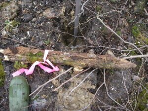
Original survey stake from the mid 1800s - time to retire!
Reduces the number boundary disputes – having a well established location to start from makes boundary determination clearer and less ambiguous.
Surveys become more accurate – With verified section corners as the base, all future surveys a more accurate.
Makes GIS more accurate – County and local government can rely upon the accurate PLSS corner locations in their CAD and GIS software to have a more precise land location and estimation for permitting, taxation, and other land information applications.
Creates secure land records for future generations – the combination of PLSS corner records publicly available and the physical monuments in the ground mean that future land and economic development will be assisted with easily attainable land records that can be verified in the field.
What does it cost to remonument, and where does the money come from?
Remonumenting is an infrastructure project that is usually funded by a combination of state and local taxes and fees. A state-wide remonumenting project can take decades to complete, so it’s generally done incrementally.
Michigan
For example, in Michigan, legislation was passed in 1990 to remonument 300,000 corners based on the original GLO Survey Plat Maps in the state (the first such statewide effort since 1855). A fund was created to pay for the effort by adding a $2-4 charge to each county recording fee. Then the money is re-allocated to each county for the project. Over the years, money in that fund was used for other things and the scope of the project was expanded, but the work still continues. As of 2019, the average completion rate by county was 71%, and the average cost per remonumentation was $857.
Wisconsin
In Wisconsin, the Wisconsin Land Information Program (WLIP) was created in 1989 to fund and maintain geospatial data. Revenue is generated from fees on real estate documents recorded within counties. In order for counties to receive funding from the WLIP, they have to have a land information plan that includes specific geospatial map layer elements. Additionally, in 2013, a state budget bill, Act 20, directed the Department of Administration to create a statewide digital parcel map in coordination with counties.
While each county is getting funding, that funding can vary widely. For example, the number of documents recorded in Milwaukee County is far higher than rural counties, such as Price or Rusk. This has created a wide gap in completion status between the two.
Highly populated areas, or places with increased land development, typically have a high number of PLSS corners fully remonumented with updated records, monuments in the ground, and coordinate locations used in their GIS parcel mapping. Many would consider those areas more in a maintenance mode of their modernization.
Conversely, in sparsely occupied counties with lower funding, it has taken decades to fully remonument only a small percentage of the area. Additionally, the task of remonumenting in rural areas may simply be more difficult as the corners may be in rugged topography, driving the cost per monument higher. This means that even if the funding were equivalent to a higher funded county, the funding would still give you less bang for your buck, so to speak.

GPS & instrument at a corner
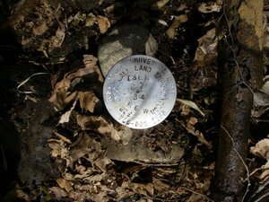
A shiny new section corner monument with an old iron pipe for 1924 laying beside it (Wisconsin).
A solid future
As more land is developed in this country, and the accuracy of land development is having more of an impact, remonumenting is more important than ever. Even with the explosive growth of GIS and the reliance on coordinate locations, data always has to be tied to physical location, and that’s where the expertise of surveyors is essential.
Surveyors are here to follow in the footsteps of the surveyors before us. As we all know, coordinate values can change. Different adjustments of datums happen every few years, and now we’re creeping up on the upcoming release of a completely new datum. The single point that ties yesterday’s survey to today’s is the physical monument in the ground. Our surveying profession requires this physical verification, and that’s what sets us apart. Surveyors don’t guess, we know. Remonumenting is a lasting testament to that need for the physical reality to give truth to the data, and everything that is derived from that data.
For more information on Michigan’s or Wisconsin’s remonumentation programs, please visit the following links:
If your state is remonumenting, check out Berntsen’s selection! We’ve been providing monuments to states and counties for nearly 50 years.

Tie sheet for the monument above.