Transforming archeology
Surveying technology brings our past to life

A traditional archeological dig in 1979. Eisenmann, L., Deetz, J., Deetz, J. & Prince, E. Excavating Feature 3. October. Retrieved from the Library of Congress,
Surveyors and engineers have a continually expanding arsenal of technology to help them plan, layout and execute projects – from brownfield development to mining to building highways. Technologies include:
LiDAR (Light Detection and Ranging), a laser scanning system used with drones for wide range spatial scanning,
3D Laser scanning for close-up highly detailed spatial data,
Total Stations , a surveying instrument that combines an electronic theodolite (for measuring angles) and an electronic distance meter (EDM) to measure both horizontal and vertical angles, as well as distances between points.
Geographic Information Systems (GIS), a computer system that analyzes and displays geographically referenced information. It uses data that is attached to a unique location
These technologies have improved the data generated by surveying activities and expanded surveying applications.

Ground-penetrating radar image of newly-discovered temple in the Roman city of Falerii Novi, Italy. Photograph: L Verdonck/PA
For example, you may have noticed a steady stream of news articles about the discovery of hidden cities and previously unknown civilizations. These discoveries are the direct result of new technologies adapted from surveying and engineering by archeologists to access a deeper and more precise view of historical artifacts.
Recent archeological discoveries
Ancient Christian settlement unearthed in Jordan, illuminating Middle East's religious past
Archaeologists uncover multistory buildings in once-thriving city lost to time
5,500-year-old ‘pyramids’ discovered during landscape work — in Central Europe
The Secret Engineering of the Nabateans in Petra: A Marvel of Ancient Hydraulics and Architecture

In October 2024 a massive Mayan city was discovered by chance by a student who analyzing LiDAR surveys using GIS.
Archeology
Archaeology studies people in the past, their activities and actions, cultural practices, tools and technological development, and in some cases (where possible) their superstitious and religious practices, expression of their cultural identity and other beliefs about themselves or the world around them.[1] It’s important to understand past cultures to help put our present civilization in perspective – and in some cases, recover knowledge that has been lost in the sweep of history.
For example, analyses of ancient remedies and medical practices, such as the use of honey for its antimicrobial properties or the development of surgical techniques, have informed the development of modern medicine and treatments. Just recently, scientists have discovered the properties that gave Roman cement the ability “heal” itself[2], which will lead to improving modern concrete construction.
Surveying and archeology
The use of surveying techniques is not new to archeology, becoming a formal practice in the early 20th Century.
Previously, most archeology was basically treasure-hunting, such as the trench excavation of Troy[3].

An example of a stratigraphic profile, courtesy of Crow Canyon Archeological Center.
Around the turn of the century, scholars started to carefully survey and document sites, recording not just artifacts but also their context and relationships to other findings. This change in approach allowed for a more thorough understanding of past civilizations.
Later, stratigraphic excavation techniques became standard practice. This is where archaeologists carefully remove and record layers of soil to reconstruct the chronology of a site. [4]
By the 1980s surveying instruments, photography, and detailed mapping techniques were used to enhance the accuracy and reliability of archaeological investigations.
Archeology is transformed

GNSS has become an integral component of archaeology as users are able to pinpoint significant finds and compile them in a GIS system with data and images, thus eliminating paperwork and saving archaeologists hours of time. Photo from XYHT.
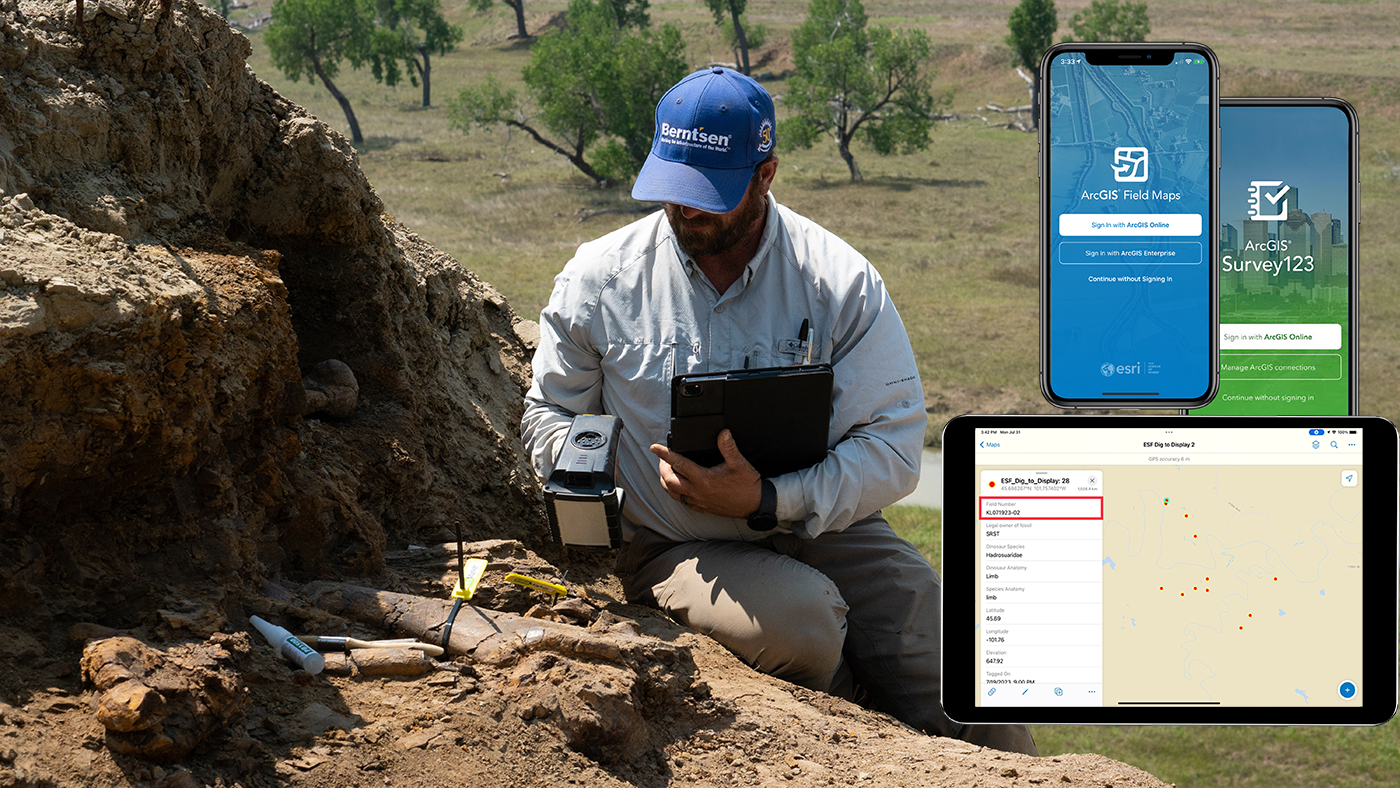
InfraMarker RFID tagging dinosaur fossils linked to Esri’s GIS, providing permanent identification and tracking of artifacts.
Today, technology has transformed the practices of surveying and archeology. Archeological surveys are routinely conducted before any land development project. “Surveys of archaeological resources help in the decision-making process regarding what can and cannot be constructed on a site and what historical findings should not be dug up during development.
The absence of a proper survey exposes the development projects to unforeseen costs and delays, especially if significant archaeological remains are found during such constructions.”[5]
Several types of archeological surveys are used, depending on project needs.
Non-Intrusive Surveys are conducted with drones or aircraft using LiDAR and ground-penetrating radar or magnetometry. These techniques can identify subsurface features and patterns with no excavation.
Intrusive Surveys include test excavations, borehole drilling and trenching which provide detailed information on stratigraphy, artifacts and structures. Intrusive surveys are thorough, but they can permanently alter the site.
Extensive surveys cover large areas and numerous archeological sites to identify and document. They look for settlement patterns and resource distribution.
Intensive surveys focus on small-scale or site specific areas and collect detailed data using non-intrusive and intrusive methods.
As the archeological dig progresses, other tools are often brought into get more data from the excavation.
Magnetometers: Measure variations in the Earth's magnetic field caused by buried features like walls or pits.
Resistivity Meters: Detect subsurface features by measuring electrical resistance in the soil, useful for identifying foundations or ditches.
Gradiometers: Specialized magnetometers for detecting subtle magnetic variations.
GPS Devices: For accurate positioning and georeferencing of survey areas.
Infrared Sensors: Detect heat variations, which can indicate human-made features beneath the surface.[5]
RFID: once artifacts are located and identified, they can be RFID-tagged and linked to GIS. This allows researchers to track any artifact as it is removed from the dig for study. It’s data and location are always available with a scan, preventing documentation errors and promoting shared insights. Read a case study here.
Archeological surveying is just the latest field that has benefitted from technological advancements. As more and more of our past is identified, studied and shared, we not only have a better understanding of our past, but also how the modern world is still developing.