Key Trends Shaping Asset Management in 2026
And Why it Matters for Infrastructure
The infrastructure world is changing fast. Owners, utilities, environmental groups, campuses, and municipalities are all under increasing pressure to keep assets accurate, connected, compliant, and maintained. Budgets aren’t growing. Workforces aren’t expanding. Yet expectations are rising.
Heading into 2026, one theme is clear: the organizations that will succeed are those that simplify, consolidate, and streamline the systems that run their infrastructure.
Here are the key trends reshaping asset management going into 2026—and how InfraMarker is helping organizations meet this moment.
Trend 1: Simplifying Systems and Reducing Tech-Stack Overload

Organizations are tired of juggling multiple disconnected tools. Field staff use one app, inspectors another, GIS teams rely on something else, and asset managers try to tie it all together at the end. The result is slow adoption, inconsistent data, and constant training challenges.
The trend for 2026 is consolidation: fewer systems, more connected workflows, and intuitive field tools that reduce complexity rather than add to it.
Why it matters:
Infrastructure projects run on thin margins and tight schedules; complexity slows everything down.
InfraMarker’s role: Connects RFID, inspections, and field data directly into ArcGIS. No extra software stack added.
Trend 2: One Source of Truth for Asset Data
Fragmented asset information is one of the biggest challenges in infrastructure. Photos live in cloud drives, coordinates live in field apps, inspections sit in PDFs, and IDs are buried in spreadsheets. When data is scattered, decision-making slows and risk increases.
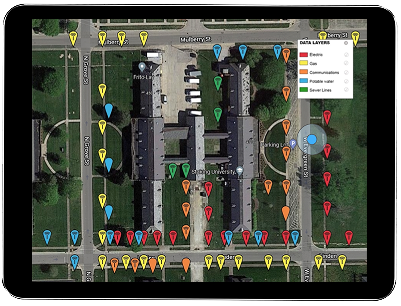
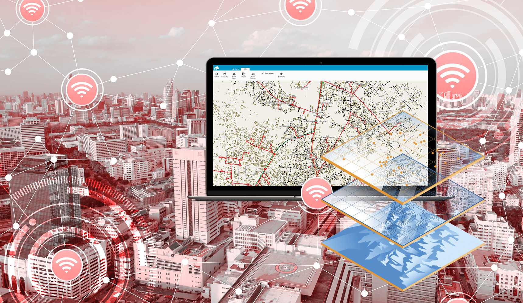
In 2026, organizations are pushing aggressively toward a single system of record. For most, that system is Geographic Information Systems (GIS).
Why it matters:
Infrastructure owners face increasing regulatory pressure and liability; bad data = real risk.
InfraMarker’s role: Locks each physical asset to its digital identity, keeping everything accurate inside GIS.

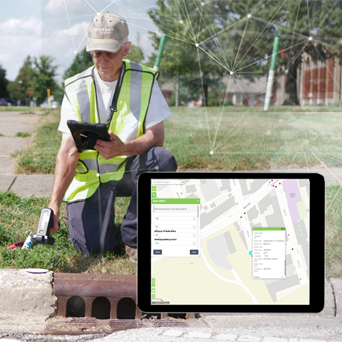
Trend 3: Workflow Improvement Through Field-Ready Technology
In the field, workers need simplicity, not complexity. They want workflows that load fast, work offline, and capture data accurately without typing long strings of numbers. Every unnecessary step is compounded across thousands of assets and dozens of crew members.
2026 is the year of eliminating extra clicks, simplifying capture, and giving field crews tools they actually like to use.
Why it matters:
Asset accuracy is determined at the moment of capture. If the data starts wrong, every downstream decision is wrong.
InfraMarker’s role: One-tap RFID reads auto-fill IDs, reduce errors, and streamline data capture in Field Maps and Survey123.
Trend 4: Asset Management Maturity Moves Front and Center
Infrastructure owners are moving from “locate it” to manage it for 30+ years.
2026 marks a shift toward long-term management of every asset, including:
Inspection histories
Condition records
Maintenance logs
Replacement forecasting
Full lifecycle documentation
Asset management maturity is no longer optional; it’s essential to proper management.
Why it matters:
Most infrastructure costs happen after installation. Without long-term asset tracking, organizations lose visibility, miss maintenance windows, and pay more over time.
InfraMarker’s role: InfraMarker creates a persistent link between the physical asset and its digital record, keeping every inspection and condition update tied to the same long-term identity.
Trend 5: GIS Becomes the Operational Anchor
GIS is no longer just a map. It’s becoming the operational backbone of infrastructure. Engineering, permitting, construction, inspections, and maintenance increasingly revolve around the spatial context of GIS.
In 2026, the expectation is simple: if it exists, it should exist in GIS.
Why it matters:
Spatial insight improves safety, reduces dig risks, speeds permitting, ensures compliance, and strengthens public transparency - essential for public infrastructure owners.
InfraMarker’s role: InfraMarker is GIS-native. It works directly with ArcGIS Online and Enterprise, and integrates with Survey123 and Field Maps, ensuring that every asset is born digital, is spatially oriented, and connected.
Trend 6: AI-Assisted Workflows Make Teams More Efficient
AI is quickly moving into asset management, not to replace people, but to help them:
Detect missing or inconsistent data
Recommend next inspection steps
Flag at-risk assets
Automate routine QA/QC tasks
Predict maintenance needs
AI is only as good as the data feeding it.
Why it matters:
Infrastructure industries face severe labor shortages. AI helps teams process more information with fewer people.
InfraMarker’s role: InfraMarker provides structured, clean asset data; exactly the fuel AI models need.
Why These Trends Matter for Infrastructure Industries

Infrastructure assets are aging faster than they can be replaced.
Organizations face increasing regulatory scrutiny and rising risk around asset failure.
Most owners operate with squeezed budgets and shrinking workforces.
More data is being collected than ever, but much of it is inconsistent, incomplete, or siloed.
These trends drive a shift toward efficiency, accountability, and accuracy, enabling:
Faster field operations
Fewer mistakes
Lower long-term maintenance costs
Better compliance documentation
Stronger transparency for public stakeholders
How InfraMarker Helps Infrastructure Organizations Meet These Trends
InfraMarker is designed around the realities of infrastructure work:
✔ 1. Simplifies the tech stack
One solution connects RFID hardware to GIS; no additional software required.
✔ 2. Creates a single source of truth
Each asset gets a permanent, RFID-linked digital identity in ArcGIS.
✔ 3. Streamlines Field Workflows
One-tap reads, auto-filled IDs, fewer errors, and faster workflows.
✔ 4. Supports long-term lifecycle management
Persistent asset IDs keep inspection, maintenance, and history connected for decades
✔ 5. Strengthens GIS as the operational system
Native integration with Survey123, Field Maps, and the ArcGIS platform.
✔ 6. Builds a foundation for AI readiness
Clean data inputs enable reliable predictive insights, automated QA/QC, and smarter planning.
InfraMarker doesn't replace GIS; it strengthens it, turning it into the operational engine for long-term asset management.
Conclusion: The Shift Toward Smarter Infrastructure
Infrastructure owners must grapple with aging assets, rising complexity, and shrinking workforces. The answer isn’t more software, it's smarter systems, cleaner data, and tighter workflows.
2026 will be defined by:
Organizations doing more with less.
Better workflows, fewer systems, and stronger GIS-centric asset management.
InfraMarker is built for exactly this moment—helping infrastructure organizations simplify, connect, and future-proof their asset management strategy.
If you’d like help evaluating your current workflow or exploring an RFID + GIS integration, we’re always here to help.