Honoring surveyors who served
For more than 250 years, the capable hands of surveyors have played a key role in building and defending our country. From the colonial surveyors turned patriots, to the intrepid explorers of the Louisiana Purchase, surveyors were key to the founding of our nation.
As the nation grew, surveyors led the way, by surveying and mapping the frontier and planning communities. They also played a key role in the defense of the country.
Officers of the U.S. Army Corps of Topographical Engineers and the modern U.S. Army Corps of Engineers are legendary for their contributions to national infrastructure, exploration, and wartime efforts.
A surveyor of the west
James Hervey Simpson was one of the first officers transferred to the newly-created Corps of Topographical Engineers in 1838. In this role, he assisted in harbor construction on Lake Erie and later managed the port. The following year, he surveyed roads and supervised road construction in Florida, then completed lake surveys in Ohio and Wisconsin.
In 1849, Simpson was attached to an expedition to the West, surveying a road from Fort Smith, Arkansas to Santa Fe, New Mexico. With him was Richard Kern, a talented artist from Philadelphia. They encountered the living pueblo of Jemez, where Kern drew not only the Pueblo itself but some of the wall paintings in a Jemez kiva. They later discovered the ancient cliff dwellings in the Canyon de Chelly.
When he returned, Simpson wrote and published a narrative of the expedition, Reports of the Secretary of War, with Reconnaissances of Routes from San Antonio to El Paso ... and the Report of Lieut. J. H. Simpson of an Expedition into Navajo Country (1850). Simpson's report is only 112 pages long, it includes 74 lithographs based on Kern's drawings.[1]

Ancient cliff dwellings in the Canyon de Chelly drawn by Richard Kern, an artist accompanying Simpson on the expedition to the southwest.

Union army colonel and bvt brigadier general James Hervey Simpson By Guo Tianqiao - Own work, CC0.
Later, Simpson surveyed the territory of Minnesota, then was ordered to Utah, where he surveyed roads for military use and led preliminary reconnaissance into the Great Salt Lake Desert. He later returned to the Salt Lake area with an extensive expedition that produced the earliest surviving photographs of features along the trail. The Central Route surveyed by Simpson played a vital role in the transportation of mail, freight, and passengers between the established eastern states and California, especially when hostilities of the Civil War closed other routes. In 1861 the Transcontinental Telegraph was laid along the route, which only became obsolete in 1896 when transportation and telegraphy were switched to the Transcontinental Railroad, a project overseen by Simpson, now promoted to Chief Engineer of the Interior Department.
During the Civil War, Simpson served as colonel in a volunteer infantry and was captured at the Battle of Gaines's Mill. He was paroled and returned, but resigned his commission of volunteers on August 24, 1862, to return to his rank of major in the Corps of Topographical Engineers. He was attached to the Department of the Ohio and was in charge of the expansion and improvements of the defenses for Cincinnati, Ohio. For his services during the war, Simpson was brevetted to the rank of brigadier general.
In 1880 he retired to St. Paul, Minnesota, and died there at the age of 70 on March 2, 1883.
The Simpson Park Mountains in central Nevada, a small range in west-central Utah and Simpson Springs Pony Express Station are named after him.
Many American landmarks are named after surveyors, including Mount Rushmore, Mount Fremont, Mount Powell, Ferdinand Vandeveer Hayden, and so on.
The Final Point™ Project
It may be too late for today's surveyors to have mountains named after them, but the profession has its own enduring tradition of recognition. For more than two decades, Berntsen International and the National Society of Professional Surveyors Foundation have honored the lives and careers of land surveyors through the Final Point™ program.
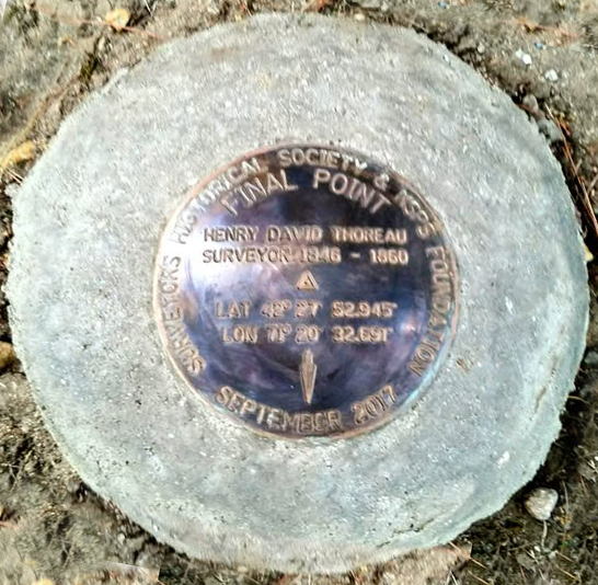
Henry David Thoreau’s Final Point in Concord, Massachusetts.
Since 2003, Final Point monuments have been placed across the country, each one a precision-cast bronze marker engraved with the surveyor's name, license number, and the latitude and longitude of their final resting place or another location of personal significance. The monuments can be set in the ground with a stem mount, presented on a plaque, or installed as part of a memorial ceremony. Past dedications have honored everyone from local mentors and family members to historic figures like Henry David Thoreau, whose Final Point was placed in Concord, Massachusetts in 2017.
Every Final Point purchase contributes directly to the NSPS Foundation Scholarship Fund, supporting the next generation of surveyors entering the profession. It's a tribute that lasts, in the most literal sense, as a permanent geodetic mark, and one that gives back to the field the honoree spent their career advancing.
What's new for 2026. Beginning in June, Berntsen along with NSPS, is launching a streamlined online ordering process for Final Point monuments and introducing a new commemorative medallion option for families, firms, and surveying societies who want to recognize a colleague without a full monument installation. The same scholarship contribution is built into every order, continuing a 23-year tradition of honoring the past while investing in the future of surveying.