Public Works:
Essential for modern (and ancient) civilizations
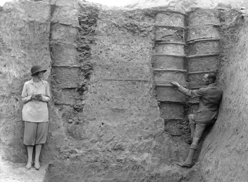
Leonard and Katharine Woolley at Ur, with ring-drains in situ. Clearly visible, between the wall of the leftmost drain shaft and the ring-drain itself, is the usual packing with potsherds to improve drainage
Public works have sustained civilizations for more than 6,000 years.
Mesopotamia (specifically the Sumerians) is widely recognized as the first civilization to develop extensive public works, starting around 4000 BCE, focused on agricultural irrigation, city walls, and sewage systems. They developed these projects to protect city-states and manage water resources, employing labor through tax-based systems known as corvee labor (that is, workers would be drafted from the general population and put to work as a form of taxation by the state.)
Key public works in early Mesopotamia (c. 4000–3000 BCE)
Irrigation Systems: Canals and dams were built to control flooding from the Tigris and Euphrates rivers and provide water to fields.
Sewage Systems: Early clay sewer pipes and specialized latrines existed in cities like Nippur and Uruk by 4000–3200 BCE.
City Walls & Infrastructure: Massive walls, temples (ziggurats), and warehouses were constructed to protect city-states and manage.
These projects were essential for maintaining urban life and were often managed by a centralized government or religious authorities, as noted in the history of Mesopotamian civilization.
Public works today
Six millennia later, public works continue to be the backbone of our modern way of life. This week we recognize the crews, supervisors, and leaders who keep our communities running. Today, it takes more than the decree of a powerful ruler to create and maintain our infrastructure. Today, public works professionals get the job done while dealing with tight budgets, aging infrastructure, and increasing expectations. For public works directors and operations staff, the challenge isn’t just doing the work, it’s doing it efficiently, defensibly, and with confidence in the data behind every decision.
That’s where modern asset management, powered by GIS and RFID, moves from “nice to have” to mission-critical.
From reactive to proactive operations
Most departments have lived the pain of reactive maintenance: emergency callouts, missed assets, incomplete records, and duplicated effort. The shift to proactive operations starts with knowing exactly what you own, where it is, and what condition it’s in.
GIS provides that operational picture. Instead of relying on fragmented records or institutional knowledge, your team has a single, spatially accurate system of record. Crews can see assets in context: how a valve connects to a main, how a culvert impacts drainage, how road conditions correlate with underlying utilities.
For directors, that means better prioritization and defensible capital planning. For operations staff, it means fewer surprises in the field.

Utilities marked with InfraMarker RFID displayed in map view on a tablet.
Closing the gap between the field and the office
Even the best system falls short if it isn’t kept current. That’s where RFID adds real operational value.
With RFID-enabled workflows, field crews can scan an asset and instantly:
Verify they’re at the correct location
Pull up maintenance history and inspection requirements
Log work performed with a timestamp and location
Update asset status in real time

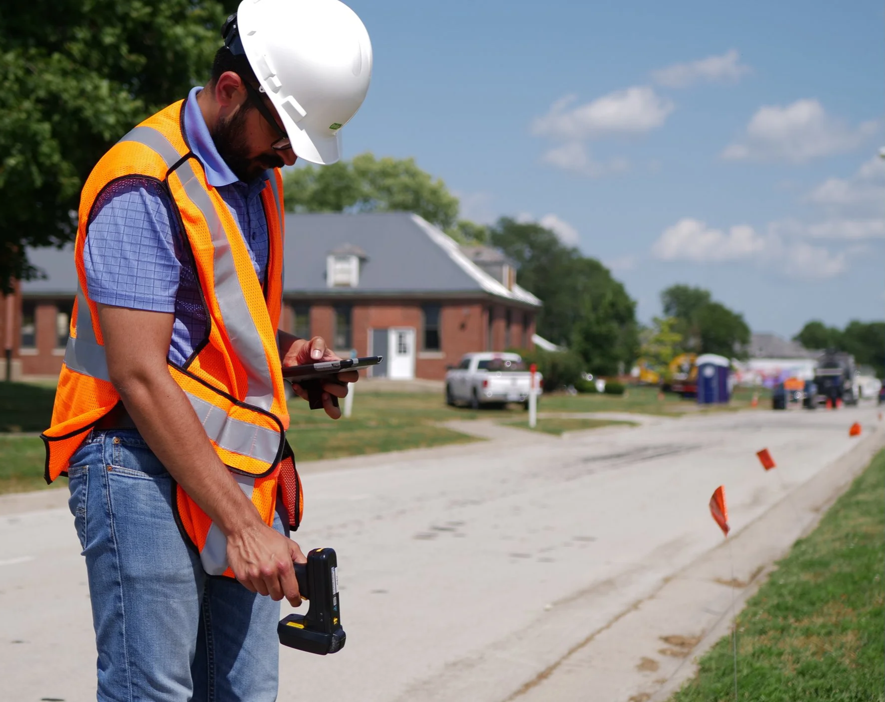
Field staff scanning a sign to launch its workflow in the InfraMarker app.
No more handwritten notes that need to be re-entered. No more uncertainty about whether an inspection actually occurred. Every scan becomes a verified event tied directly to your GIS.
For operations teams, this reduces administrative overhead and eliminates gaps in documentation. For leadership, it creates a clean, auditable record that is critical for compliance, reporting, and risk management.
Accuracy where it matters: in the field
If your crews have ever spent extra time searching for a buried valve or structure that’s “supposed to be right here,” you already understand the cost of bad location data.

Depiction of how InfraMarker RFID works with GIS to streamline the location, verification and workflow relating to asset maintainance.
RFID provides a unique identifier for the asset that is connected to GIS, providing instant in-field verification of any asset, anywhere. This benefits any department within public works with assets that require maintenance, or simply need to be immediately identified. RFID makes it easier than ever to collect precise data in the field and feed it directly into GIS.
The payoff is immediate:
Faster locate times
Reduced risk during excavation
More efficient routing and planning
Greater confidence in emergency response
Accurate data doesn’t just save time, it prevents costly mistakes.
Building a system that works the way you do
The real power comes from integration. When GIS and RFID are aligned with your workflows, you create a system that supports how your team actually operates, not one they have to work around.
Imagine a typical day:
A crew is dispatched with a clear, map-based work order
They navigate directly to the asset with confidence in its location
A quick RFID scan confirms the asset and logs their arrival
Work is completed and documented in real time
The system updates instantly: no lag, no re-entry, no ambiguity
That’s not a future-state vision, it’s an achievable operational model.
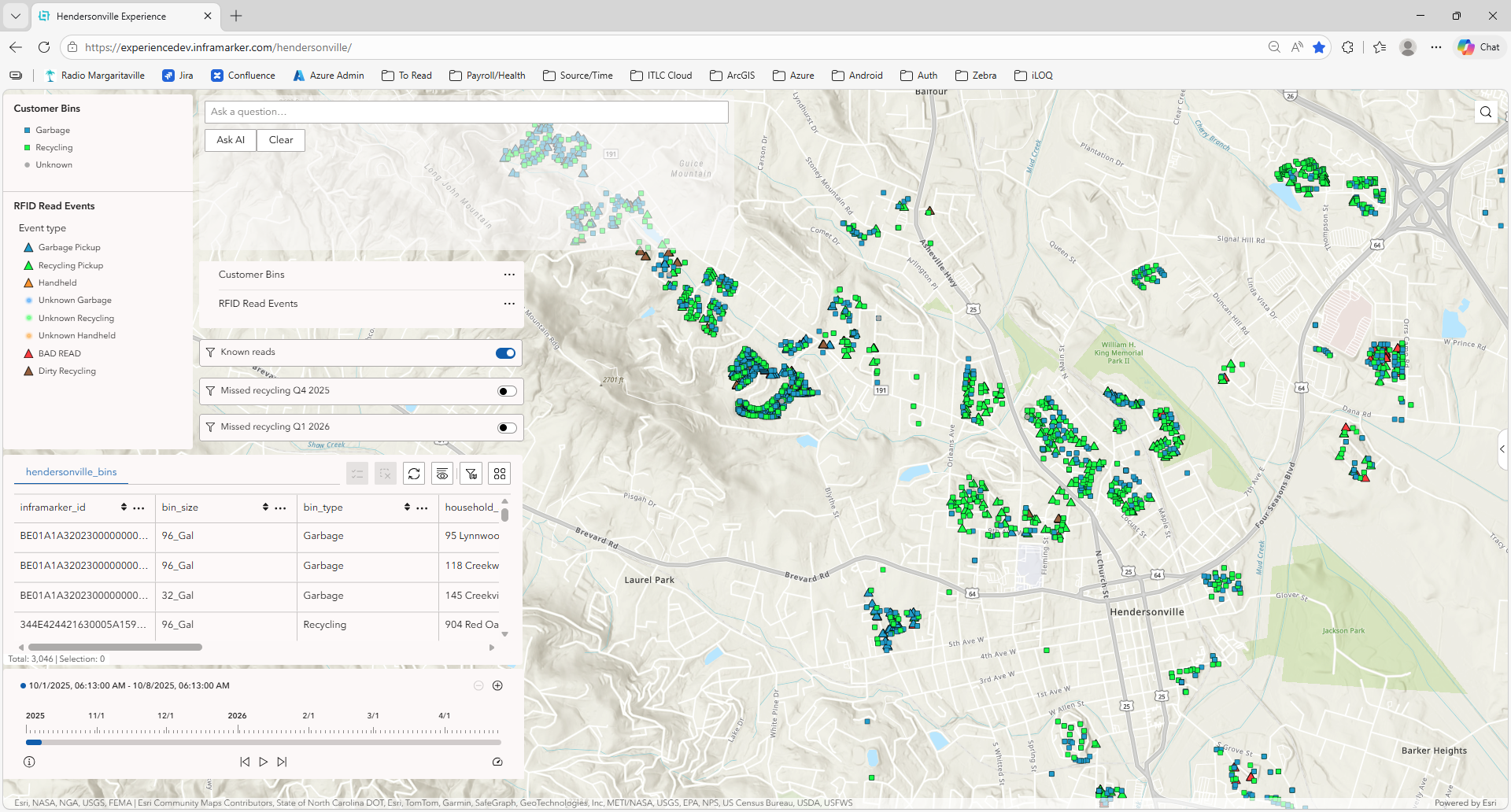
ArcGIS dashboard displaying container pickup points in Hendersonville, NC
InfraMarker RFID in action
The City of Hendersonville, North Carolina sought to modernize its residential Waste & Recycling collection. A primary issue was the lack of accurate, auditable, and real-time information to document the location and dates of pickups of waste/recycling receptacles as well as accurate data on recycling and contamination rates.
Hendersonville worked with the staff of Berntsen International, Inc., the manufacturer of InfraMarker, to develop a system that enabled thorough, complete and accurate data collection during the refuse/recycling process.
This case study describes how the use of InfraMarker enabled critical Waste & Recycling data to flow directly into Esri ArcGIS, giving the City verified pickups and measurable program performance.
Better decisions, fewer headaches
Worker scanning RFID markers
For directors, integrated asset management delivers:
Defensible budgeting and capital improvement planning
Clear visibility into asset condition and performance
Reduced liability through verified inspections and maintenance
For operations staff, it means:
Less time searching, more time working
Fewer errors and callbacks
Tools that simplify, rather than complicate, the job
Recognizing the work, and improving it
Public Works Week is about recognizing the essential work your teams do every day. It’s also an opportunity to invest in the systems that make that work more efficient, more accurate, and more sustainable.
GIS and RFID aren’t just technologies. . . .they’re force multipliers for your staff. They reduce friction, improve accountability, and give your team the confidence to operate at a higher level.
Because at the end of the day, smooth municipal operations don’t happen by accident; they’re built on good data, solid processes, and the people who bring it all together.
Header Image: Ziggurat of Ur