Before there was President's Day, there were surveyors
Whenever President’s Day rolls around, we, as surveyors, can’t help but think of the historical importance of surveying in the United States – not only because Washington, Lincoln and Jefferson were all surveyors, but the impact surveying had on the development of the nation. I’ve touched on that in blogs I’ve done about colonial surveyors, but the depth of the subject calls for a look into how surveying developed in America.

1719 map of the world, from the world view of England. Moll, Herman, 1732. “A new & correct map of the whole World”. London, 1719. Map.
Back in the 1500 and 1600s when European monarchs were looking at ways to expand their empires and their coffers, they started laying claim to any lands their ships essentially “ran into”. By 1550, the Spanish had explored most of the eastern coast of North America and the French had explored the Gulf of St. Lawrence, and each claimed all these lands for their respective rulers. The fact that the land was already occupied was not an issue to these monarchs and their representatives, since indigenous peoples didn’t have rights under their laws.
It turned out that neither Spain nor France ended up with the land, despite many years of conflict, because England was the first to figure out a way to systematically occupy and use the land.
The Corporate Approach
Back then, the English monarch actually owned all the land in England and its colonies and could grant title to any lands as he/she saw fit. However, the Crown didn’t have enough money to actually colonize America due to paying for wars. That’s where the corporate approach came in.
In England, there were three groups of people who were interested in making money in the colonies:

A large stained-glass window in Saint Helena's Church in Lincolnshire, England, with the Virginia Company's coat of arms.
The very rich merchants, traders and aristocrats who financed the cost of getting people over to America and expected the ROI to flow in as they sat in their manors.
The middle class who wanted to use their skills to build a more profitable life in the colonies so they too would end up owning their own manors.
The poor who had nothing to lose and would sign up to be indentured servants for the chance to own land after three to seven years.
The wealthy people formed companies with the intent of generating wealth from the colonies through land speculation and selling its natural resources. They sold stock to other wealthy people and the middle class. The Crown then granted the company a charter for lands in America. Then the poor and some middle-class folks were sent over to do the work and generate the ROI.
This system worked pretty well for wealth generation, so soon every European country was busy claiming lands and setting up colonies. Many of these claims overlapped, which led to skirmishes, wars and then finally agreements about who owned what. It also drove the need for accurate boundaries and the establishment of Land Tenure Systems.
A convoluted system
There were many different types of Land Tenure Systems used by the colonial governments to handle land titles.
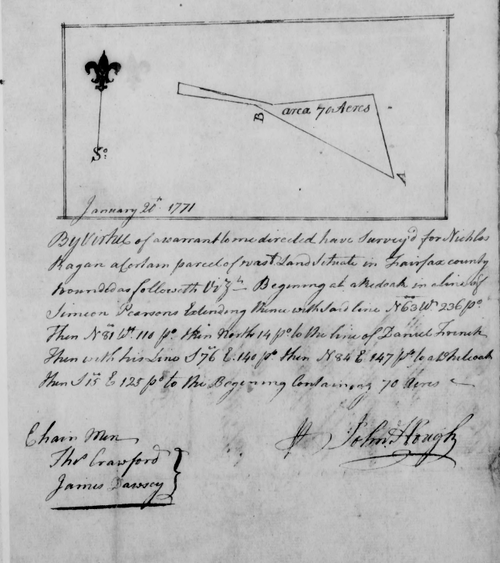
Colonial surveys were simple documents, referencing features on the ground such as red oak trees. Source: Library of Virginia.
Grants – In this system, the colonial land was granted to a settlement agency that could only keep the land if they managed to get immigrants to settle on the land.
Warrants – Soldiers who served the Crown could be paid with bounty land warrants. The soldier’s rank determined the acreage awarded.
Headrights – In southern colonies, a man was granted 50 acre or larger parcels of land if he settled it, cleared part of and made a farm. Wealthy people who paid for the passage of people to acquire these headrights also received a headright for every person they paid for, so the wealthy could acquire large holdings without leaving England.
Direct Land Sales – This happened in all of the colonies except New England, although it was not an established policy before the Revolutionary War.
Corporate Colonies – In Connecticut, Massachusetts and Rhode Island, land was held and parceled out by corporation. Basically, a group of 30 or more men would get together and apply for a land grant. If approved, they surveyed a plot of land with exterior boundaries of 6 to 10 miles square. Then they parceled out the land to each person and issued the title to them. The land in these grants couldn’t be sold without the group’s permission. This method prevented land disputes because there was no uncertainty about boundaries. Other New England states used different versions of this method.
But that’s not all . . .
Once people had been granted land, there were a range of other restrictions and fees they had to pay.
Restrictions included:
Primogeniture – the land passed from the original grantee only to his oldest son.
Entails – only lineal descendants could own the land; if there were no lineal descendants, then the land reverted to the original grantor.
Quitrent – fees that settlers had to pay to the grantor once the land was producing income.
I think it’s pretty clear that the basic structure of how the colonies were established and administered was bound to generate friction and animosity – which, over time, led to the Revolutionary War and a representative government, with an elected president rather than a king.
Surveying was Key

Eight survey tracts along the Kanawha River, W. Va. showing land granted to George Washington and others. Source, Library of Congress.
Throughout all of the change and tumult, surveying was of key importance, because the settlement companies had to know the boundaries of their land and what exactly was transferred to settlers and others. For example, the Virginia Company of London (one of the earliest settlement companies charted in 1606), first appointed a surveyor general in 1621 and the practice of surveying land before title was transferred continued. This office continued even after Virginia became a Royal Colony all the way up to the Revolutionary War. In 1779, the new Commonwealth of Virginia established the Land Office that handled the surveying.
Despite attempts to survey and document land to keep track of ownership, it was common practice for settlers to move to the outskirts of parcels of land and start their own farms, without official title or documentation. Over time, they could be awarded title to the land. At other times, the official owner would show up and they would be forced off the land.
One such notable case involved George Washington’s claim to land he’d been awarded for service in the French and Indian War and the Revolutionary War. When Washington arrived in Western Pennsylvania in 1784 to see his property, he found squatters on his land who had been there more than a decade. They claimed they owned the land, due to their work converting it to farmland. Washington then offered to sell it to them, but they thought the price of twenty-five shillings an acre to be too high. The two parties ended up in Pennsylvania Court where a jury in 1786 awarded Washington title to the 13 farms located on the property. Rather than pay Washington for the land, the settlers abandoned their farms. Washington still owned the property at the time of his death in 1799.
We’ve come a long way since then, developing the US Public Land Survey system, we’ve standardized different land transactions, and modernized land use, but we still see remnants of colonial practices today. It’s this development that has shaped our country, our land, and our profession in such a way, making it so important that continue to follow in the footsteps of those who were here before us.
Sources:
http://www.virginiaplaces.org/settleland/headright.html
https://www.lva.virginia.gov/exhibits/mapping/surveyors/index.htm