Location is Everything - and not just when buying a house!
A blog by Emily Pierce, PLS, CFedS
More than anyone, surveyors understand the importance of location. We master many types of tools to generate the specific data required for boundary lines, construction grids, laying out developments, creating 3D models of buildings and topography and more.
One of the most important tools in our kit is the magnetic locator.
I wouldn’t leave my truck without my locator – anytime I go out to do a survey, I need my locator to find the pipes from the previous survey. Here in Wisconsin, not only do we have to find survey monuments from the previous survey (if there is one), we also need to locate at least two PLSS corners to tie our survey to. That can be a challenge, especially in certain parts of the state.
Once, when I was surveying for the county, the corner restoration record told us the iron pipe marking the section corner was supposed to be in the middle of a busy road. When I scanned the location with my locator, I immediately found a buried nail. I continued scanning and rang up a couple more nails, a piece of ½ inch rebar – all in a hole 6 inches in diameter. At about 18 inches deep, we finally found the iron pipe marking the section corner. It was satisfying to find the pipe, but it sure was interesting finding all of the miscellaneous markers that had been set over the last 20 years above the corner monument! This experience, and other similar situations made me wish for a survey marker that could actually “talk” to us and tell us its location!

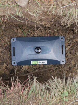
InfraMarker RFID tag
It’s kind of ironic that, now that I work for Berntsen, I’m helping to promote a marker that does actually tell you about itself – by using RFID. It sure would be nice if section corners (or underground gas lines, fiber optic cables, etc.) were marked with InfraMarker tags. The subsurface InfraMarker tags have reverse polarity magnets, so if you’re using something like a Schonestedt GA-72, you can see immediately where the tag is buried without confusing it with some other buried metal. Once you locate the RFID tag, a quick scan reveals the asset or corner type, owner, and latitude and longitude. Plus, if you’re using GIS or asset management software, the RFID tag data can be tied to its record in the software, providing precise asset and location information.
When I was surveying, I relied on my Schonstedt locator to quickly find buried markers. If I would have had the opportunity, I would have purchased a PINK Schonstedt locator. This isn’t just because it’s pink. It’s because every year in October, Schonstedt donates a portion of the proceeds from the sales to the Breast Cancer Research Foundation (BCRF) as part of National Breast Cancer Awareness month. BCRF is a non-profit organization is committed to finding both a cure and a way to prevent breast cancer. It has an “A” rating from CharityWatch, and 88% of all donations are spent supporting research.
This is personal to me, because I have several close family members who have fought / are fighting breast cancer.
Berntsen is supporting this promotion by offering a limited number of pink Schonstedt 52Cx-BC locators during October. This locator is a pink version of the popular GA-52Cx.
Additionally, Berntsen will donate a portion of the proceeds for ALL Schonstedt products sold in October 2020 to BCRF. So, if you don’t want a pink locator you can still support the cause by ordering any Schonstedt product from Berntsen in October.
You can have a look at them and order them here.
Location, location, location – it’s what we’re all about – and helping a good cause.
