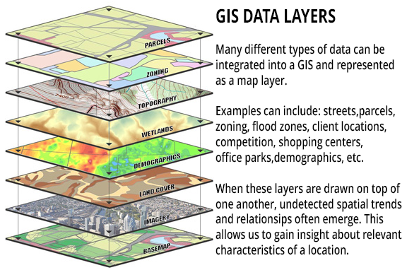
GIS - Location intelligence that makes everything smarter
Today is Geographic Information Systems (GIS) Day!
GIS connects location to data – delivering a unique way to visualize and address complex, multi-dimensional challenges. It is also phenomenally versatile and easily integrates with other technologies. Today GIS is experiencing significant growth, expanding across nearly every industry, from urban planning and environmental management to public health and business operations.

Dr. Snow’s waterworks map of 1846 from the UCLA Epidemiology John Snow Site
How GIS was developed
GIS first appeared as a map created by Dr. John Snow in 1854. He plotted all of the cholera outbreak locations in London, along with roads, property boundaries and water lines. His map revealed that cholera outbreaks were clustered around a water pump, challenging the existing notion that cholera was spread through the air. Along with creating one of the first uses of Geographic Information, Dr. Snow also is credited with starting the field of Epidemiology.
Soon, plotting data on maps became more common – besides public health applications, insurance companies used them to plot fires and thereby compute insurance rates, governmental tax offices plotted property lands to evaluate tax rates, and natural resource departments plotted wetland areas, flood zones, and water bodies to help protect our waterways and natural habitats. More and more types of data were plotted on maps, but it was painstaking work.
Roger Tomlinson was a British-trained geographer and geologist who worked for the Government of Canada and for an Ottowa-based aerial survey company. While working on a project to identify the best location for a tree plantation in Kenya, Tomlinson partnered with IBM to find a way to bridge the gap between geographic data and computer services. This initiative was eventually extended to create a national mapping system that created maps of Canada’s commercially-leveraged land used for agriculture, forestry, wildlife and recreation. It was during this project that Tomlinson created the term “Geographic Information Systems” to describe his synthesis of computer mapping with capabilities for overlay, measurement and digitizing.
2020 – GIS Today
On the basis of Tomlinson’s use of geographic location and computing power, a multi-billion dollar industry is now thriving and impacting almost every aspect of modern life.
Drivers of GIS importance
Solving complex problems: GIS is crucial for tackling global challenges like climate change, sustainability, and social inequity by providing the tools to analyze and visualize geographic data.
Market and job growth: The GIS market is projected to grow substantially, and there is increasing demand for professionals with spatial data skills, often within the context of other fields like data science and software development.
Technological integration: GIS is evolving and integrating with other technologies such as AI, machine learning, the Internet of Things (IoT), Radio Frequency Identification (RFID) and big data to enable more sophisticated and automated analysis.
Ubiquitous application: GIS is moving from a niche tool to an essential necessity in both public and private sectors. It is used by governments for resource management and infrastructure planning, and by businesses for logistics and decision-making.
Enhanced communication and critical thinking: GIS allows for the communication of complex ideas through compelling maps and visualizations, and its use helps foster critical spatial thinking skills.
How GIS is evolving
Integration with data science: Traditional GIS is being absorbed into the broader fields of data science and computer science.
Automation: Artificial intelligence and machine learning are automating data collection, processing, and analysis, leading to more autonomous and sophisticated GIS applications.
Wider adoption: As more organizations recognize the business value of geospatial data, the adoption of GIS is becoming more widespread and is transforming how various technologies are utilized.
New applications of GIS and RFID
When field verification of assets is essential, RFID delivers accurate tracking of any item – from fish to buried infrastructure.
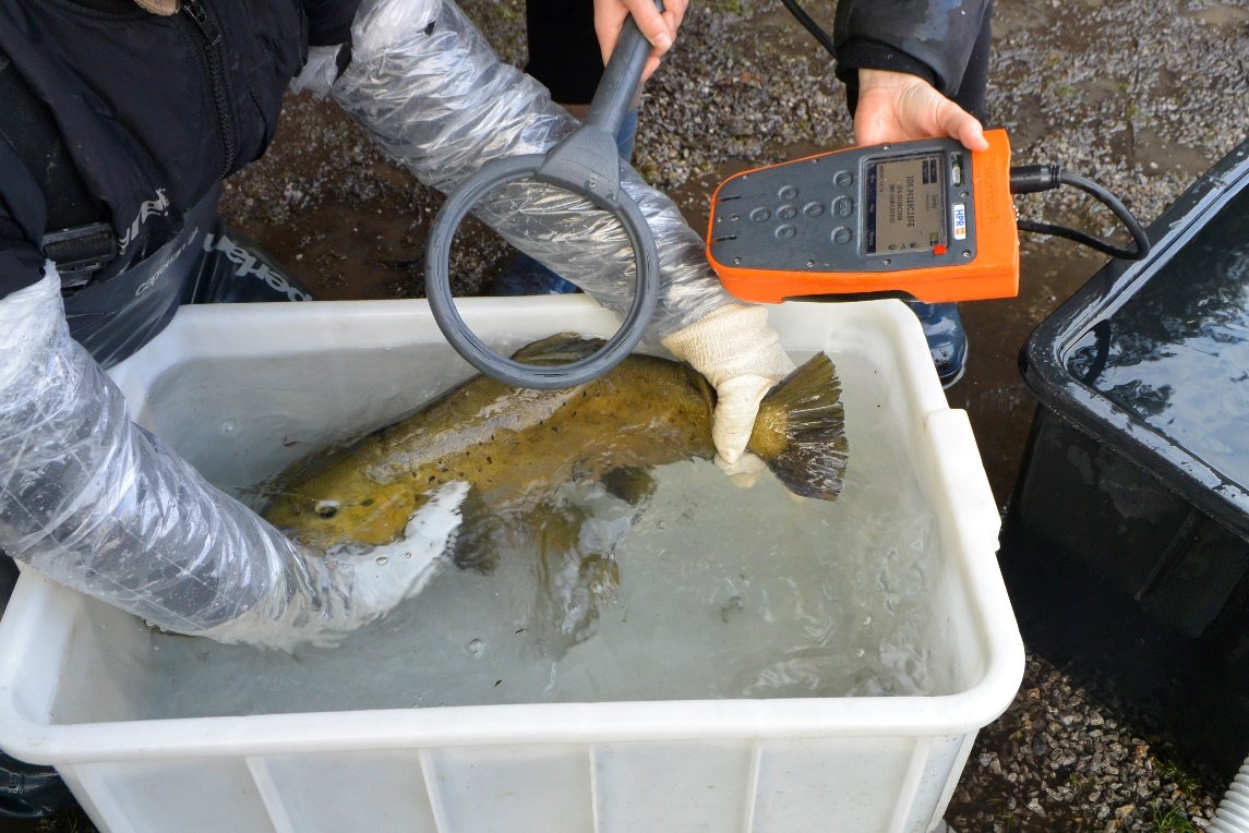
GIS and RFID deliver accurate fish tracking for environmental studies
RFID Automates Fish Tracking: The Oregon Department of Fish and Wildlife (ODFW) monitors the impact of stream diversion on fish populations. To track fish, they use Biomark Passive Integrated Transponder (PIT) tags, implanted just under the skin, which enable quick re-identification. Integrating InfraMarker RFID with ArcGIS data collection apps dramatically reduced tagging time, minimized data errors, and improved overall field efficiency. ODFW expects the time savings and accuracy achieved through this solution to benefit ongoing and future fisheries and environmental studies. Read the case study.
RFID Transforms Dinosaur Bone Asset Management: Tracking and managing artifacts at archaeological excavations, through transport to research facilities, museum display and storage has been a persistent issue with no universal solution. This study examines the novel application of existing technologies to track, manage and share data from 347 dinosaur bone fossils from dig to display. Read the case study.
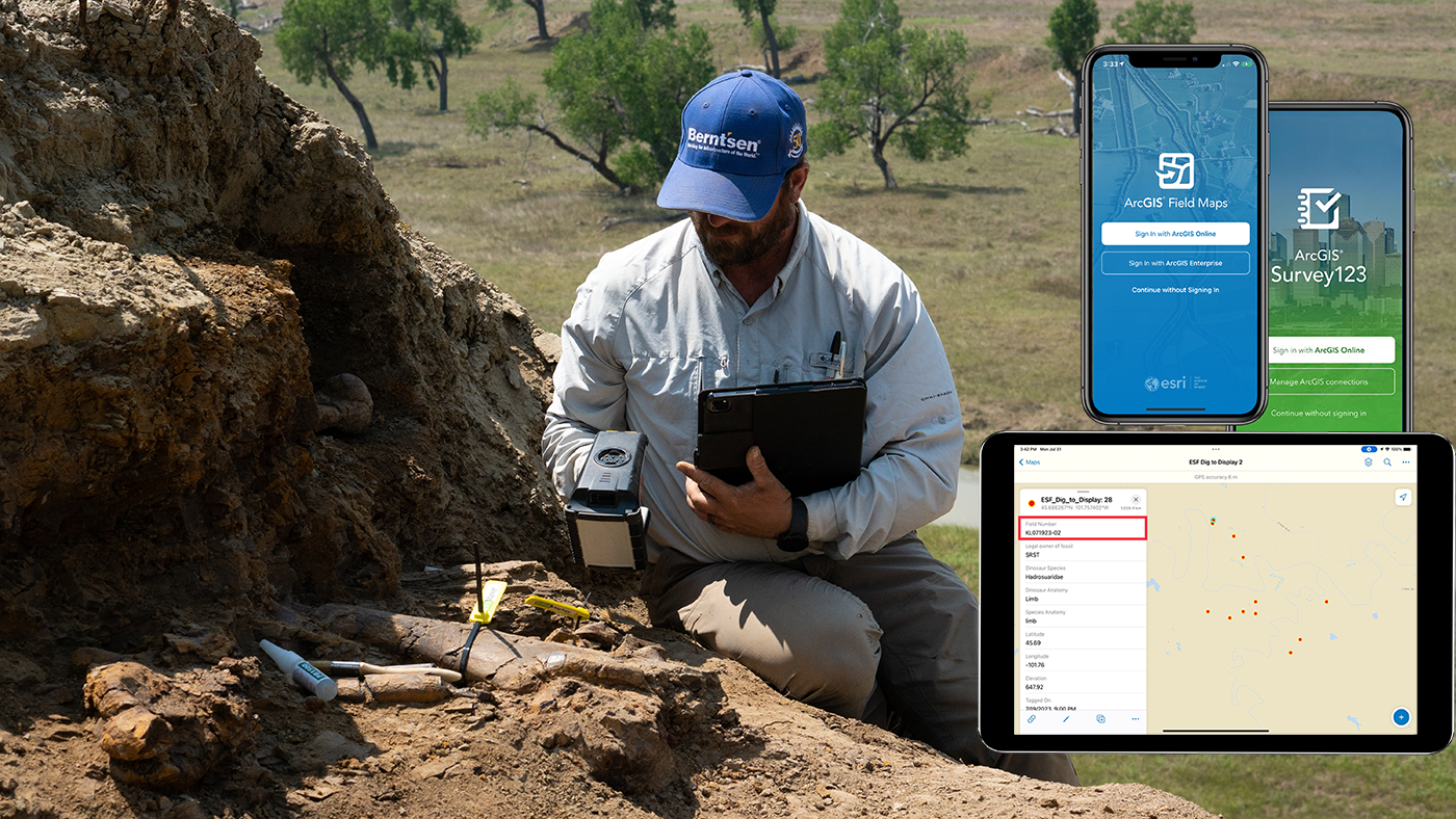
RFID helps archeologists track fossils from dig to display.
RFID Secures Chain-of-Custody: In many industries and domestic programs, a secure chain of custody is essential to insure program integrity. From supply chains to managing the security of election ballots, RFID is providing real-time, verified tracking of sensitive assets.
RFID Improves Waste Management Programs: Accurate data related to waste management improves GIS management of waste and recycling programs. Using RFID to track recycling and waste pick-up rates, cities are able gain important insights about the success of their programs. RFID and the InfraMarker app allows data to flow into Esri’s ArcGIS in real time, providing insights into how customers are actually participating in specific recycling efforts.
RFID Helps Municipalities Manage Stormwater Reporting Requirements: Municipalities that receive federal funding to help build and maintain their stormwater assets must report their progress to the government. RFID and and GIS deliver tracking and data essential for the proper management of the utility while generating auditable records for program progress reports.

RFID provides real-time feedback on recycling program participation.
RFID Streamlines Underground Utility Asset Tracking: Accurate locating and identifying of underground assets are critical for damage prevention. A longitundial study explores how three technologies – GIS, RFID, and magnetic marking – impact the speed and reliability of finding identifying, and managing underground utilities. The 7-year study finds that multi-factor approach of connecting GIS with RFID/magnetic in-ground markers best improves underground utility management performance. Read the case study.
Radio Frequency Identification (RFID), used with Geographic Information Systems (GIS) is a powerful, versatile approach to managing nearly every type of asset across time and space. From fish to cattle to underground valves, GIS and RFID deliver real-time, accurate data for management, analysis and planning.

View of buried infrastructure assets in GIS earth view.
RFID provides the connection between the digital world of GIS and the real world with on-site verification of any asset anywhere. Learn how it works.