

Emperor Marcus Aurelius (161–180 AD) shows his clemency towards the vanquished after his success against Germanic tribes; bas relief from the Arch of Marcus Aurelius, Rome, now in the Capitoline Museum. Image by MatthiasKabel - Own work, CC BY-SA 3.0,
From Roman battlefields to modern desert warfare, surveyors have helped armies navigate unfamiliar terrain, position their forces, and make critical strategic decisions. Their work often happens behind the scenes, but military operations depend on knowing exactly where you are, and what lies ahead.
From Roman Camps to Imperial Conquests
Ancient Roman armies understood the importance of knowing the land. Military surveyors helped select defensible camp locations and lay out walls, ditches, roads, headquarters, supply areas, and barracks. This standardized approach allowed soldiers to establish organized camps wherever their campaigns took them[1].
Surveying also helped Rome control conquered territories. Surveyors divided land into organized parcels for settlement, administration, and taxation. Mapping was more than a technical exercise; it helped transform conquered landscapes into functioning parts of the Roman Empire.
Centuries later, European powers relied on maps to plan military campaigns and expand their empires. Detailed surveys helped armies navigate difficult terrain, while maps documented territorial claims and supported overseas exploration and colonization.[2] [3]
Mapping a Revolution

Rocque, J., Dury, A. & Rocque. (1761) A general map of North America; in which is express'd the several new roads, forts, engagements, &c. taken from actual surveys and observations made in the army employ'd there, from the year , to 1761. [London, M.A. Rocque, ? Retrieved from the Library of Congress
During the American Revolutionary War, British military surveyors produced detailed maps of the colonies, documenting everything from hills and swamps to roads, buildings, and fences. These maps helped commanders plan troop movements and military campaigns.[4]

Mulberry harbor assembled in preparation for the invasion of Normandy, with military vehicles crossing a floating roadway.
But knowing the terrain wasn't enough. Despite their detailed maps, the British underestimated the determination of the colonists; a reminder that even the best geographic intelligence cannot account for every factor in a conflict.[5]
The Civil War: When Maps Changed the Battlefield
During the American Civil War, accurate maps were essential to reconnaissance and military strategy. The Union benefited from its trained Corps of Topographical Engineers, while Confederate forces also produced valuable maps through individual surveyors.[6]
One notable example was Jedediah Hotchkiss, a former schoolteacher and geologist who mapped Virginia's Shenandoah Valley for Confederate General Stonewall Jackson. His detailed work helped Jackson navigate the valley and execute rapid, unexpected movements.[7]
On the Union side, engineer Gouverneur K. Warren recognized the strategic importance of Little Round Top at Gettysburg. His assessment of the terrain helped Union forces defend a critical position.
In both cases, understanding the landscape could influence the outcome of a battle.
D-Day: Surveying the Way to Normandy
The Allied invasion of Normandy on June 6, 1944, depended on far more than ships and troops. Specialized British survey teams, known as Combined Operations Pilotage Parties (COPP), gathered critical information about landing beaches, tides, water depths, and the ground's ability to support military vehicles.[8]
This intelligence helped planners determine where and when Allied forces could land. On D-Day, more than 156,000 Allied troops crossed the English Channel to begin the liberation of Western Europe.
The success of the operation depended in part on surveyors who gathered vital information under dangerous conditions before the invasion began.
Vietnam: Surveying Under Fire
In Vietnam, surveyors played a critical role in establishing artillery positions, coordinating fire, and supporting the construction of roads and bridges.
Artillery units depended on accurate coordinates and directional control to engage targets. Surveyors also served as forward observers in dangerous environments, where they had to work under difficult conditions while helping coordinate military operations.
Their work connected precise measurements on the ground with decisions that could determine the success of a mission.[9]
The Gulf War: GPS Transforms Military Surveying
By the 1990–1991 Gulf War, satellite positioning was changing how military surveyors worked.
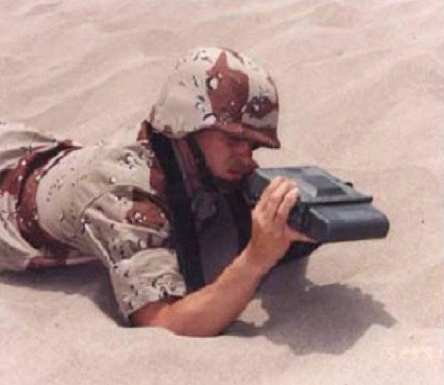
A soldier holds one of the small lightweight GPS receivers used during Operation Desert Storm in 1991. (U.S. Air Force photo)
U.S. Army survey teams in Saudi Arabia had to establish accurate control points across vast stretches of desert to support artillery positioning. Traditional surveying methods would have been too slow, so teams used emerging GPS technology to extend control networks toward the Iraqi border.
The effort covered approximately 10,000 square kilometers and established 95 control points. Surveyors worked to stay ahead of advancing artillery units, sometimes driving into the desert to mark new positions with stakes and lights.
It was a turning point: surveying was evolving from traditional line-of-sight measurements toward satellite-supported positioning on a much larger scale.[10]
A Mission That Never Ends
From the standardized camps of ancient Rome to GPS-enabled operations in the Gulf War, military surveyors have helped turn unfamiliar terrain into actionable intelligence.
Their tools have evolved dramatically, but their mission remains remarkably consistent: establish accurate positions, understand the landscape, and give commanders reliable information for critical decisions.
This Veterans Day, we recognize the surveyors, engineers, and service members whose skill, ingenuity, and dedication have helped protect their fellow service members and support military operations throughout history.
Footnotes:
[1] Roman Groma: Ancient Rome's Surveying Tool | UNRV Roman History
[2] The History of Cartography, Volume 3: Cartography in the European Renaissance, Part 1
[3] (PDF) The Cartographer Sets Sail: Eyewitness Records and Early Modern Maps
[4] https://www.berntseninternational.com/articles/before-there-was-presidents-day-there-were-surveyors
[5] https://www.berntseninternational.com/articles/surveyors-key-to-our-independence
[7] Jedediah Hotchkiss - Wikipedia
[8] https://www.berntseninternational.com/articles/operation-overlord
[9] https://www.berntseninternational.com/articles/memorial-day
[10] https://devilofhistory.wordpress.com/2017/06/22/stakes-in-the-sand-surveying-in-the-gulf-war/